Uetersen night lights from space
Night Light of Uetersen (Schleswig-Holstein) from space (Germany) Src. Average luminocity for 10x10km area is 10.6982% and for 50x50km: 16.5588%.
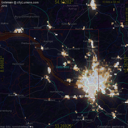
Analysis of Uetersen night lights 2016
Square area 10x10 km:
 0.51%
0.51%90-99
2.02%80-89
1.14%70-79
0.88%60-69
1.26%50-59
0.76%40-49
1.89%30-39
0.63%20-29
0.51%10-19
14.02%0-9
76.39%Square area 50x50 km:
5.55%90-99
3.82%80-89
1.16%70-79
1.31%60-69
1.63%50-59
1.14%40-49
1.65%30-39
1.47%20-29
2.07%10-19
6.91%0-9
73.3%Clear (daylight) street map image can be seen on geolist.org.
Map coordinates:
54° 6' 7.3" North, 8° 57' 39" East
53° 41' 15.7" North, 9° 39' 50.2" East
53° 16' 9.3" North, 10° 22' 1.5" East
Some cities around Uetersen sort by population:
• Elmshorn
7.4 km =4.6 mi,  354°
354°
• Pinneberg
8.6 km =5.3 mi,  105°
105°
• Wedel
11.8 km =7.3 mi,  168°
168°
• Halstenbek
13.7 km =8.5 mi,  116°
116°
• Rellingen
10.9 km =6.8 mi, 112°
• Tornesch
3.7 km =2.3 mi,  68°
68°
• Barmstedt
13.5 km =8.4 mi,  30°
30°
• Appen
6.3 km =3.9 mi, 121°
2818067 (p: 17,921)
Sources (retrieved 2019-11-25):
» Earth at Night: Flat Maps 2012, 2016