Tacherting night lights from space
Night Light of Tacherting (Bavaria) from space (Germany) Src. Average luminocity for 10x10km area is 1.5% and for 50x50km: 3.408%.
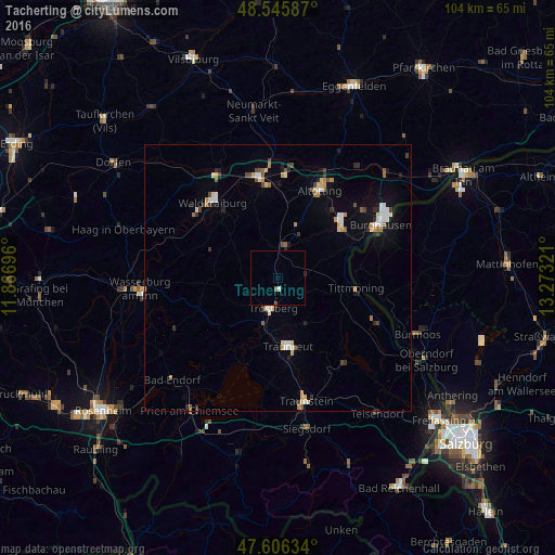
Analysis of Tacherting night lights 2016
Square area 10x10 km:
 0%
0%90-99
0.6%80-89
0%70-79
0%60-69
0%50-59
0.74%40-49
0.15%30-39
0%20-29
0%10-19
0%0-9
98.51%Square area 50x50 km:
0.43%90-99
0.51%80-89
0.43%70-79
0.43%60-69
0.32%50-59
0.33%40-49
0.52%30-39
0.29%20-29
0.48%10-19
1.22%0-9
95.03%Clear (daylight) street map image can be seen on geolist.org.
Map coordinates:
48° 32' 45.1" North, 11° 52' 1.1" East
48° 4' 41.7" North, 12° 34' 12.3" East
47° 36' 22.8" North, 13° 16' 23.6" East
Some cities around Tacherting sort by population:
• Waldkraiburg
19.3 km =12 mi,  318°
318°
• Traunreut
13 km =8.1 mi,  172°
172°
• Mühldorf
19.1 km =11.9 mi,  349°
349°
• Altötting
18.2 km =11.3 mi,  25°
25°
• Trostberg an der Alz
5.7 km =3.5 mi,  189°
189°
• Burgkirchen an der Alz
15.6 km =9.7 mi,  50°
50°
• Garching an der Alz
6.3 km =3.9 mi,  7°
7°
• Tittmoning
14.8 km =9.2 mi,  97°
97°
2824420 (p: 5,704)
Sources (retrieved 2019-11-25):
» Earth at Night: Flat Maps 2012, 2016