Sulz am Neckar night lights from space
Night Light of Sulz am Neckar (Baden-Württemberg) from space (Germany) Src. Average luminocity for 10x10km area is 1.3026% and for 50x50km: 3.0987%.
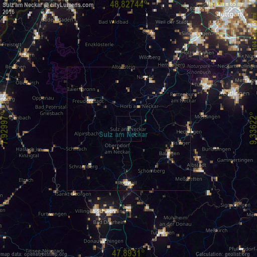
Analysis of Sulz am Neckar night lights 2016
Square area 10x10 km:
 0%
0%90-99
0%80-89
0%70-79
0%60-69
0%50-59
1.14%40-49
0.57%30-39
0%20-29
0.57%10-19
0.57%0-9
97.16%Square area 50x50 km:
0.19%90-99
0.3%80-89
0.4%70-79
0.42%60-69
0.34%50-59
0.56%40-49
0.66%30-39
0.67%20-29
0.58%10-19
0.59%0-9
95.28%Clear (daylight) street map image can be seen on geolist.org.
Map coordinates:
48° 49' 38.8" North, 7° 55' 47.9" East
48° 21' 44.7" North, 8° 37' 59.1" East
47° 53' 35.2" North, 9° 20' 10.4" East
Some cities around Sulz am Neckar sort by population:
• Horb am Neckar
10.1 km =6.3 mi,  25°
25°
• Oberndorf
9.2 km =5.7 mi,  209°
209°
• Haigerloch
12.6 km =7.8 mi,  88°
88°
• Dornstetten
15.7 km =9.8 mi,  320°
320°
• Loßburg
14.2 km =8.8 mi,  287°
287°
• Rosenfeld
10.8 km =6.7 mi,  141°
141°
• Dornhan
9.3 km =5.8 mi,  261°
261°
• Geislingen
15.6 km =9.7 mi,  122°
122°
2824855 (p: 12,763)
Sources (retrieved 2019-11-25):
» Earth at Night: Flat Maps 2012, 2016