Haigerloch night lights from space
Night Light of Haigerloch (Baden-Württemberg) from space (Germany) Src. Average luminocity for 10x10km area is 0.1335% and for 50x50km: 4.9438%.
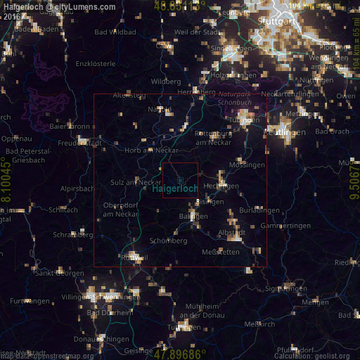
Analysis of Haigerloch night lights 2016
Square area 10x10 km:
 0%
0%90-99
0%80-89
0%70-79
0%60-69
0%50-59
0%40-49
0%30-39
0%20-29
0%10-19
0%0-9
100%Square area 50x50 km:
0.31%90-99
0.5%80-89
0.58%70-79
0.66%60-69
0.67%50-59
0.77%40-49
0.87%30-39
0.98%20-29
0.6%10-19
2.66%0-9
91.4%Clear (daylight) street map image can be seen on geolist.org.
Map coordinates:
48° 49' 52.1" North, 8° 6' 1.6" East
48° 21' 58.1" North, 8° 48' 12.9" East
47° 53' 48.7" North, 9° 30' 24.1" East
Some cities around Haigerloch sort by population:
• Balingen
10.8 km =6.7 mi,  159°
159°
• Horb am Neckar
12 km =7.5 mi,  316°
316°
• Hechingen
11.9 km =7.4 mi,  97°
97°
• Sulz am Neckar
12.6 km =7.8 mi,  268°
268°
• Bisingen
10.5 km =6.5 mi,  126°
126°
• Rosenfeld
10.7 km =6.6 mi,  213°
213°
• Geislingen
8.7 km =5.4 mi,  175°
175°
• Rangendingen
6.6 km =4.1 mi,  74°
74°
2911960 (p: 10,828)
Sources (retrieved 2019-11-25):
» Earth at Night: Flat Maps 2012, 2016