Steinheim am Albuch night lights from space
Night Light of Steinheim am Albuch (Baden-Württemberg) from space (Germany) Src. Average luminocity for 10x10km area is 6.1339% and for 50x50km: 6.0971%.
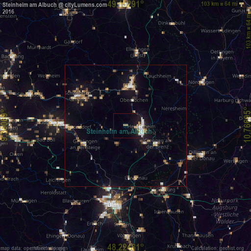
Analysis of Steinheim am Albuch night lights 2016
Square area 10x10 km:
 0.15%
0.15%90-99
0.15%80-89
0.6%70-79
0%60-69
2.98%50-59
0%40-49
0%30-39
0.45%20-29
0.3%10-19
13.39%0-9
81.99%Square area 50x50 km:
0.61%90-99
0.64%80-89
0.65%70-79
0.55%60-69
0.74%50-59
0.92%40-49
0.88%30-39
1.01%20-29
0.96%10-19
5.14%0-9
87.9%Clear (daylight) street map image can be seen on geolist.org.
Map coordinates:
49° 9' 10.5" North, 9° 21' 38.5" East
48° 41' 27.2" North, 10° 3' 49.8" East
48° 13' 28.6" North, 10° 46' 1" East
Some cities around Steinheim am Albuch sort by population:
• Heidenheim an der Brenz
6.6 km =4.1 mi,  102°
102°
• Herbrechtingen
11.3 km =7 mi,  133°
133°
• Gerstetten
8.3 km =5.2 mi,  203°
203°
• Oberkochen
10.8 km =6.7 mi,  16°
16°
• Königsbronn
6.8 km =4.2 mi,  31°
31°
• Nattheim
13.1 km =8.1 mi,  85°
85°
• Essingen
13.4 km =8.3 mi,  348°
348°
• Böhmenkirch
9.6 km =6 mi,  264°
264°
2827989 (p: 9,013)
Sources (retrieved 2019-11-25):
» Earth at Night: Flat Maps 2012, 2016