Schwarzheide night lights from space
Night Light of Schwarzheide (Brandenburg) from space (Germany) Src. Average luminocity for 10x10km area is 9.0829% and for 50x50km: 2.19%.
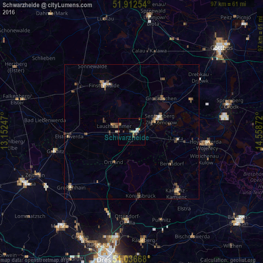
Analysis of Schwarzheide night lights 2016
Square area 10x10 km:
 1.34%
1.34%90-99
1.87%80-89
0%70-79
1.34%60-69
1.6%50-59
0.8%40-49
1.47%30-39
1.2%20-29
0.53%10-19
0%0-9
89.84%Square area 50x50 km:
0.14%90-99
0.23%80-89
0.14%70-79
0.36%60-69
0.35%50-59
0.44%40-49
0.54%30-39
0.52%20-29
0.28%10-19
0.26%0-9
96.74%Clear (daylight) street map image can be seen on geolist.org.
Map coordinates:
51° 54' 45.1" North, 13° 9' 8.9" East
51° 28' 36.2" North, 13° 51' 20.1" East
51° 2' 12" North, 14° 33' 31.4" East
Some cities around Schwarzheide sort by population:
• Senftenberg
11.5 km =7.1 mi,  61°
61°
• Lauchhammer
6.3 km =3.9 mi,  281°
281°
• Finsterwalde
20.3 km =12.6 mi,  329°
329°
• Großräschen
16.4 km =10.2 mi,  41°
41°
• Doberlug-Kirchhain
26.2 km =16.3 mi,  309°
309°
• Elsterwerda
23.3 km =14.5 mi,  265°
265°
• Schipkau
5.4 km =3.4 mi,  32°
32°
• Bernsdorf
18.7 km =11.6 mi,  127°
127°
2834740 (p: 6,646)
Sources (retrieved 2019-11-25):
» Earth at Night: Flat Maps 2012, 2016