Schliersee night lights from space
Night Light of Schliersee (Bavaria) from space (Germany) Src. Average luminocity for 10x10km area is 1.7426% and for 50x50km: 2.918%.
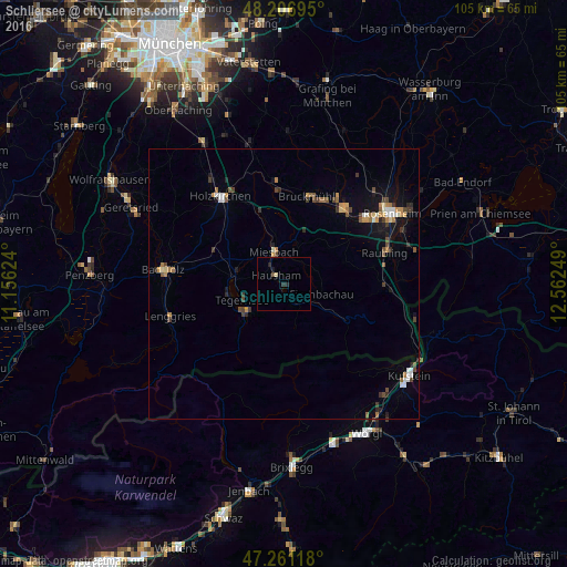
Analysis of Schliersee night lights 2016
Square area 10x10 km:
 0%
0%90-99
0.15%80-89
0.45%70-79
0%60-69
0%50-59
0.15%40-49
0.45%30-39
0.15%20-29
1.49%10-19
0.74%0-9
96.43%Square area 50x50 km:
0.29%90-99
0.33%80-89
0.18%70-79
0.44%60-69
0.47%50-59
0.32%40-49
0.57%30-39
0.57%20-29
0.48%10-19
1.62%0-9
94.72%Clear (daylight) street map image can be seen on geolist.org.
Map coordinates:
48° 12' 25" North, 11° 9' 22.5" East
47° 44' 10.4" North, 11° 51' 33.7" East
47° 15' 40.2" North, 12° 33' 45" East
Some cities around Schliersee sort by population:
• Bruckmühl
16.3 km =10.1 mi,  13°
13°
• Miesbach
6.2 km =3.9 mi,  341°
341°
• Hausham
1.8 km =1.1 mi,  309°
309°
• Bad Feilnbach
12 km =7.5 mi,  69°
69°
• Gmund am Tegernsee
9.2 km =5.7 mi,  280°
280°
• Fischbachau
7.1 km =4.4 mi,  105°
105°
• Waakirchen
14.5 km =9 mi,  286°
286°
• Rottach-Egern
8.4 km =5.2 mi,  232°
232°
2838502 (p: 6,416)
Sources (retrieved 2019-11-25):
» Earth at Night: Flat Maps 2012, 2016