Reiskirchen night lights from space
Night Light of Reiskirchen (Hesse) from space (Germany) Src. Average luminocity for 10x10km area is 2.3757% and for 50x50km: 3.6463%.
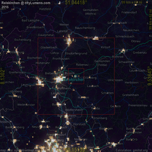
Analysis of Reiskirchen night lights 2016
Square area 10x10 km:
100  0%
0%
90-99 0%
80-89 0.53%
70-79 0%
60-69 0.53%
50-59 0.53%
40-49 0.53%
30-39 1.07%
20-29 0.53%
10-19 0.53%
0-9 95.72%
0%90-99
0%80-89
0.53%70-79
0%60-69
0.53%50-59
0.53%40-49
0.53%30-39
1.07%20-29
0.53%10-19
0.53%0-9
95.72%Square area 50x50 km:
100 0.53%
90-99 0.57%
80-89 0.26%
70-79 0.33%
60-69 0.66%
50-59 0.39%
40-49 0.48%
30-39 0.38%
20-29 0.44%
10-19 2.79%
0-9 93.16%
0.53%90-99
0.57%80-89
0.26%70-79
0.33%60-69
0.66%50-59
0.39%40-49
0.48%30-39
0.38%20-29
0.44%10-19
2.79%0-9
93.16%Clear (daylight) street map image can be seen on geolist.org.
Map coordinates:
51° 2' 39" North, 8° 7' 48.7" East
50° 36' 0" North, 8° 49' 60" East
50° 9' 5.7" North, 9° 32' 11.2" East
Some cities around Reiskirchen sort by population:
• Gießen
11.2 km =7 mi,  262°
262°
• Grünberg
8.9 km =5.5 mi,  94°
94°
• Lich
8.9 km =5.5 mi,  188°
188°
• Laubach
12.8 km =8 mi,  120°
120°
• Lollar
10.4 km =6.5 mi,  299°
299°
• Staufenberg
9.9 km =6.2 mi,  313°
313°
• Heuchelheim
14.2 km =8.8 mi, 262°
• Rabenau
8.9 km =5.5 mi,  14°
14°
2848543 (p: 10,734)
Sources (retrieved 2019-11-25):
» Earth at Night: Flat Maps 2012, 2016