Lollar night lights from space
Night Light of Lollar (Hesse) from space (Germany) Src. Average luminocity for 10x10km area is 8.1257% and for 50x50km: 3.9162%.
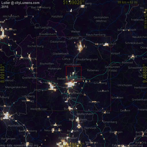
Analysis of Lollar night lights 2016
Square area 10x10 km:
 0.8%
0.8%90-99
0.27%80-89
0%70-79
1.07%60-69
2.27%50-59
0.4%40-49
0.27%30-39
0.67%20-29
0.67%10-19
18.05%0-9
75.53%Square area 50x50 km:
0.56%90-99
0.58%80-89
0.26%70-79
0.35%60-69
0.69%50-59
0.41%40-49
0.6%30-39
0.48%20-29
0.43%10-19
3.05%0-9
92.57%Clear (daylight) street map image can be seen on geolist.org.
Map coordinates:
51° 5' 24.9" North, 8° 0' 6.6" East
50° 38' 47.5" North, 8° 42' 17.8" East
50° 11' 54.8" North, 9° 24' 29.1" East
Some cities around Lollar sort by population:
• Gießen
6.9 km =4.3 mi,  197°
197°
• Lich
16 km =9.9 mi,  150°
150°
• Gladenbach
16.1 km =10 mi,  327°
327°
• Reiskirchen
10.4 km =6.5 mi,  119°
119°
• Staufenberg
2.5 km =1.6 mi,  47°
47°
• Heuchelheim
8.7 km =5.4 mi,  215°
215°
• Lohra
10.9 km =6.8 mi, 332°
• Rabenau
11.7 km =7.3 mi,  72°
72°
2876027 (p: 10,143)
Sources (retrieved 2019-11-25):
» Earth at Night: Flat Maps 2012, 2016