Maisach night lights from space
Night Light of Maisach (Bavaria) from space (Germany) Src. Average luminocity for 10x10km area is 19.186% and for 50x50km: 13.8324%.
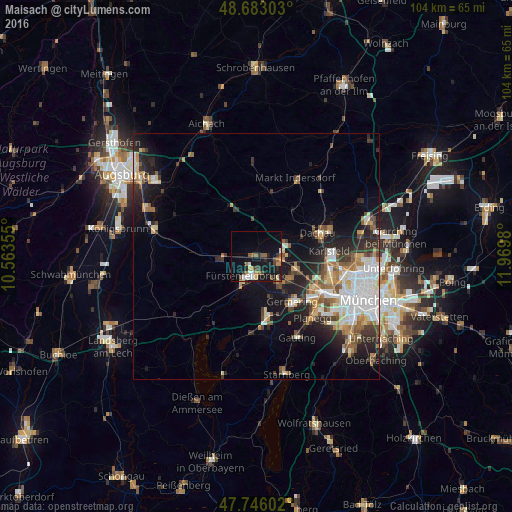
Analysis of Maisach night lights 2016
Square area 10x10 km:
 2.23%
2.23%90-99
2.23%80-89
1.34%70-79
0.89%60-69
4.91%50-59
3.57%40-49
2.08%30-39
2.83%20-29
3.27%10-19
22.02%0-9
54.61%Square area 50x50 km:
2.76%90-99
2.59%80-89
1.37%70-79
1.29%60-69
1.86%50-59
1.89%40-49
1.62%30-39
1.96%20-29
3.96%10-19
8.02%0-9
72.67%Clear (daylight) street map image can be seen on geolist.org.
Map coordinates:
48° 40' 58.9" North, 10° 33' 48.8" East
48° 13' 0" North, 11° 16' 0" East
47° 44' 45.7" North, 11° 58' 11.3" East
Some cities around Maisach sort by population:
• Germering
12.3 km =7.6 mi,  138°
138°
• Fürstenfeldbruck
4.3 km =2.7 mi,  191°
191°
• Olching
5.3 km =3.3 mi,  110°
110°
• Puchheim
9.6 km =6 mi, 140°
• Gröbenzell
7.6 km =4.7 mi,  104°
104°
• Eichenau
6.7 km =4.2 mi,  146°
146°
• Bergkirchen
8.5 km =5.3 mi,  58°
58°
• Emmering
3.9 km =2.4 mi,  161°
161°
2874200 (p: 12,507)
Sources (retrieved 2019-11-25):
» Earth at Night: Flat Maps 2012, 2016