Karlsfeld night lights from space
Night Light of Karlsfeld (Bavaria) from space (Germany) Src. Average luminocity for 10x10km area is 39.253% and for 50x50km: 20.3657%.
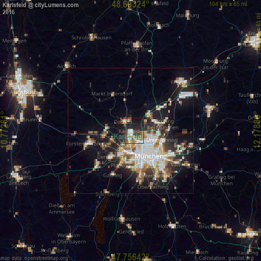
Analysis of Karlsfeld night lights 2016
Square area 10x10 km:
 5.65%
5.65%90-99
5.8%80-89
1.34%70-79
3.87%60-69
6.7%50-59
9.97%40-49
5.95%30-39
6.1%20-29
22.32%10-19
27.08%0-9
5.21%Square area 50x50 km:
4.2%90-99
4.13%80-89
1.95%70-79
1.95%60-69
2.43%50-59
2.51%40-49
2.36%30-39
2.83%20-29
5.39%10-19
12.8%0-9
59.45%Clear (daylight) street map image can be seen on geolist.org.
Map coordinates:
48° 41' 35.7" North, 10° 46' 21.4" East
48° 13' 37.1" North, 11° 28' 32.6" East
47° 45' 23.1" North, 12° 10' 43.9" East
Some cities around Karlsfeld sort by population:
• Dachau
4.8 km =3 mi,  319°
319°
• Pasing
9.6 km =6 mi,  188°
188°
• Unterschleißheim
9.6 km =6 mi,  51°
51°
• Olching
11 km =6.8 mi,  254°
254°
• Gröbenzell
8.6 km =5.3 mi, 249°
• Oberschleißheim
7.2 km =4.5 mi,  69°
69°
• Bergkirchen
8.8 km =5.5 mi,  291°
291°
• Hebertshausen
7 km =4.3 mi,  353°
353°
2892874 (p: 17,920)
Sources (retrieved 2019-11-25):
» Earth at Night: Flat Maps 2012, 2016