Jestetten night lights from space
Night Light of Jestetten (Baden-Württemberg) from space (Germany) Src. Average luminocity for 10x10km area is 4.5% and for 50x50km: 7.2254%.
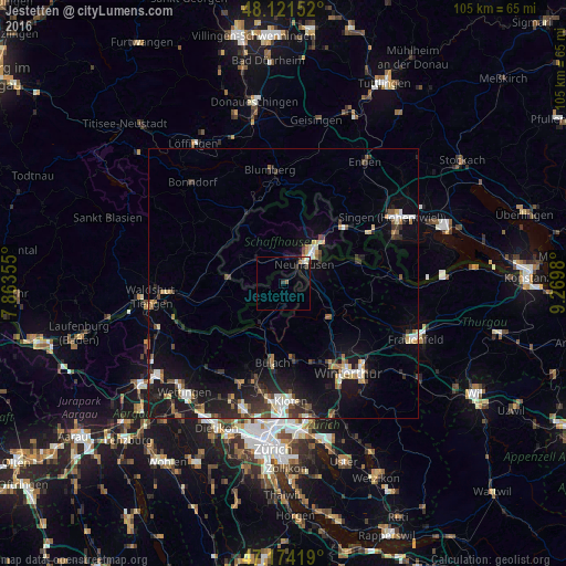
Analysis of Jestetten night lights 2016
Square area 10x10 km:
 0.15%
0.15%90-99
1.49%80-89
0%70-79
0.3%60-69
0.6%50-59
0.6%40-49
0.3%30-39
1.79%20-29
0.3%10-19
1.79%0-9
92.71%Square area 50x50 km:
0.78%90-99
1.09%80-89
0.72%70-79
0.61%60-69
0.71%50-59
0.82%40-49
1.06%30-39
1.32%20-29
2.23%10-19
7.17%0-9
83.49%Clear (daylight) street map image can be seen on geolist.org.
Map coordinates:
48° 7' 17.5" North, 7° 51' 48.8" East
47° 39' 0" North, 8° 34' 0" East
47° 10' 27.1" North, 9° 16' 11.3" East
Some cities around Jestetten sort by population:
• Schaffhausen, CH
7.3 km =4.5 mi,  44°
44°
• Bülach, CH
14.4 km =8.9 mi,  187°
187°
• Wülflingen (Kreis 6), CH
17.8 km =11.1 mi,  150°
150°
• Gottmadingen
18.4 km =11.4 mi,  58°
58°
• Neuhausen, CH
5.4 km =3.4 mi, 42°
• Embrach, CH
16.2 km =10.1 mi,  172°
172°
• Wutöschingen
15 km =9.3 mi,  274°
274°
• Stühlingen
13.9 km =8.6 mi,  320°
320°
2894944 (p: 5,171)
Sources (retrieved 2019-11-25):
» Earth at Night: Flat Maps 2012, 2016