Embrach night lights from space
Night Light of Embrach (Zurich) from space (Switzerland) Src. Average luminocity for 10x10km area is 11.7557% and for 50x50km: 14.8596%.
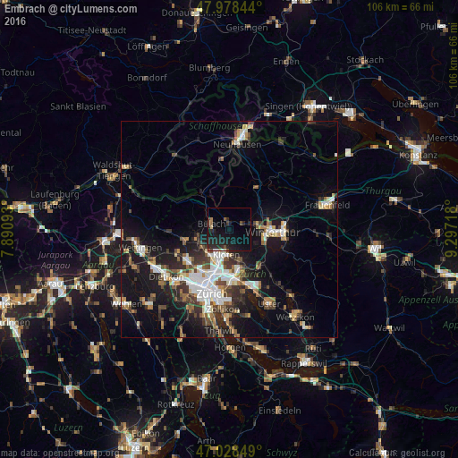
Analysis of Embrach night lights 2016
Square area 10x10 km:
 0.43%
0.43%90-99
0.57%80-89
0.99%70-79
0%60-69
1.14%50-59
1.28%40-49
2.41%30-39
1.28%20-29
10.51%10-19
18.04%0-9
63.35%Square area 50x50 km:
2.59%90-99
2.54%80-89
1.2%70-79
1.24%60-69
1.87%50-59
1.56%40-49
2.4%30-39
2.53%20-29
3.88%10-19
12.08%0-9
68.11%Clear (daylight) street map image can be seen on geolist.org.
Map coordinates:
47° 58' 42.4" North, 7° 53' 27.3" East
47° 30' 20.2" North, 8° 35' 38.6" East
47° 1' 42.6" North, 9° 17' 49.8" East
Some cities around Embrach sort by population:
• Kloten
6.1 km =3.8 mi,  186°
186°
• Stadt Winterthur (Kreis 1)
9.5 km =5.9 mi,  97°
97°
• Bülach
4.4 km =2.7 mi,  294°
294°
• Wülflingen (Kreis 6)
6.7 km =4.2 mi,  85°
85°
• Veltheim (Kreis 5)
9.3 km =5.8 mi,  84°
84°
• Töss (Kreis 4)
8.6 km =5.3 mi,  110°
110°
• Bassersdorf
7.4 km =4.6 mi,  159°
159°
• Rümlang
7.8 km =4.8 mi,  218°
218°
2660913 (p: 7,088)
Sources (retrieved 2019-11-25):
» Earth at Night: Flat Maps 2012, 2016