Egelsbach night lights from space
Night Light of Egelsbach (Hesse) from space (Germany) Src. Average luminocity for 10x10km area is 27.0672% and for 50x50km: 29.0959%.
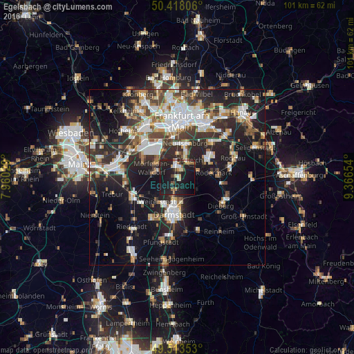
Analysis of Egelsbach night lights 2016
Square area 10x10 km:
 2.24%
2.24%90-99
2.66%80-89
4.62%70-79
2.1%60-69
2.8%50-59
1.54%40-49
4.2%30-39
1.82%20-29
14.15%10-19
53.5%0-9
10.36%Square area 50x50 km:
5.98%90-99
5.76%80-89
2.45%70-79
2.85%60-69
3.6%50-59
2.91%40-49
3.86%30-39
4.82%20-29
10.3%10-19
17.68%0-9
39.77%Clear (daylight) street map image can be seen on geolist.org.
Map coordinates:
50° 25' 5" North, 7° 57' 37" East
49° 58' 4.5" North, 8° 39' 48.3" East
49° 30' 48.7" North, 9° 21' 59.5" East
Some cities around Egelsbach sort by population:
• Darmstadt
10.7 km =6.6 mi,  185°
185°
• Dreieich
6.2 km =3.9 mi,  21°
21°
• Langen
2.4 km =1.5 mi,  8°
8°
• Neu Isenburg
9.2 km =5.7 mi, 13°
• Dietzenbach
9.4 km =5.8 mi,  60°
60°
• Mörfelden-Walldorf
6.4 km =4 mi,  297°
297°
• Weiterstadt
8.9 km =5.5 mi,  216°
216°
• Erzhausen
1.8 km =1.1 mi, 218°
2933246 (p: 9,645)
Sources (retrieved 2019-11-25):
» Earth at Night: Flat Maps 2012, 2016