Dußlingen night lights from space
Night Light of Dußlingen (Baden-Württemberg) from space (Germany) Src. Average luminocity for 10x10km area is 7.2102% and for 50x50km: 9.5454%.
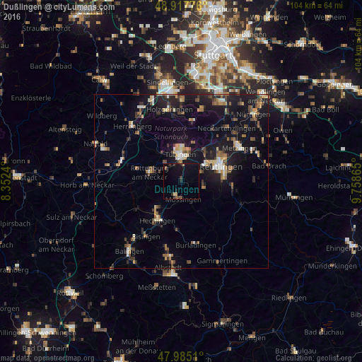
Analysis of Dußlingen night lights 2016
Square area 10x10 km:
 0%
0%90-99
0%80-89
1.7%70-79
0%60-69
0.57%50-59
0.71%40-49
0.99%30-39
2.27%20-29
1.28%10-19
9.23%0-9
83.24%Square area 50x50 km:
0.67%90-99
1.06%80-89
0.97%70-79
1.03%60-69
1.45%50-59
1.55%40-49
1.22%30-39
1.53%20-29
2.25%10-19
10.71%0-9
77.55%Clear (daylight) street map image can be seen on geolist.org.
Map coordinates:
48° 55' 3.9" North, 8° 21' 8.6" East
48° 27' 12.9" North, 9° 3' 19.9" East
47° 59' 6.4" North, 9° 45' 31.1" East
Some cities around Dußlingen sort by population:
• Tübingen
7.7 km =4.8 mi,  358°
358°
• Rottenburg
9.2 km =5.7 mi,  285°
285°
• Mössingen
5.3 km =3.3 mi,  181°
181°
• Gomaringen
3 km =1.9 mi,  90°
90°
• Kusterdingen
9 km =5.6 mi,  31°
31°
• Bodelshausen
9.2 km =5.7 mi,  218°
218°
• Kirchentellinsfurt
11.1 km =6.9 mi,  37°
37°
• Wannweil
9.9 km =6.2 mi, 44°
2934235 (p: 5,286)
Sources (retrieved 2019-11-25):
» Earth at Night: Flat Maps 2012, 2016