Bad Salzdetfurth night lights from space
Night Light of Bad Salzdetfurth (Lower Saxony) from space (Germany) Src. Average luminocity for 10x10km area is 1.048% and for 50x50km: 3.2187%.
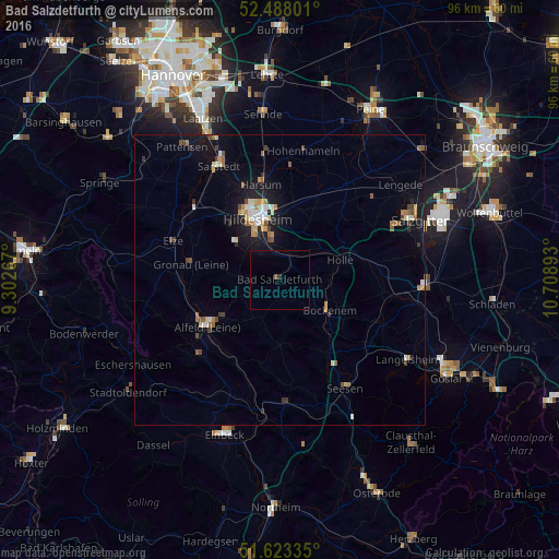
Analysis of Bad Salzdetfurth night lights 2016
Square area 10x10 km:
 0%
0%90-99
0%80-89
0%70-79
0%60-69
0.38%50-59
0.13%40-49
0%30-39
0%20-29
0.51%10-19
0%0-9
98.99%Square area 50x50 km:
0.31%90-99
0.44%80-89
0.29%70-79
0.47%60-69
0.43%50-59
0.49%40-49
0.51%30-39
0.24%20-29
0.34%10-19
2.82%0-9
93.66%Clear (daylight) street map image can be seen on geolist.org.
Map coordinates:
52° 29' 16.8" North, 9° 18' 9.6" East
52° 3' 28" North, 10° 0' 20.9" East
51° 37' 24.1" North, 10° 42' 32.1" East
Some cities around Bad Salzdetfurth sort by population:
• Hildesheim
11 km =6.8 mi,  340°
340°
• Alfeld
15.1 km =9.4 mi,  237°
237°
• Bockenem
10.1 km =6.3 mi,  121°
121°
• Giesen
17.1 km =10.6 mi,  334°
334°
• Schellerten
15.6 km =9.7 mi,  24°
24°
• Holle
11 km =6.8 mi,  72°
72°
• Diekholzen
7.3 km =4.5 mi,  305°
305°
• Gronau
15.9 km =9.9 mi,  280°
280°
2953362 (p: 14,349)
Sources (retrieved 2019-11-25):
» Earth at Night: Flat Maps 2012, 2016