Alfeld night lights from space
Night Light of Alfeld (Lower Saxony) from space (Germany) Src. Average luminocity for 10x10km area is 7.6124% and for 50x50km: 2.363%.
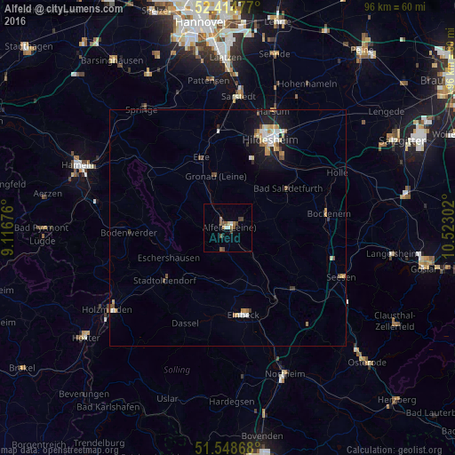
Analysis of Alfeld night lights 2016
Square area 10x10 km:
 0.88%
0.88%90-99
0.63%80-89
0.51%70-79
0.51%60-69
1.77%50-59
1.77%40-49
2.78%30-39
0.76%20-29
0%10-19
0.63%0-9
89.77%Square area 50x50 km:
0.33%90-99
0.38%80-89
0.21%70-79
0.43%60-69
0.31%50-59
0.26%40-49
0.33%30-39
0.18%20-29
0.27%10-19
1.76%0-9
95.54%Clear (daylight) street map image can be seen on geolist.org.
Map coordinates:
52° 24' 53.2" North, 9° 7' 0.3" East
51° 59' 1.8" North, 9° 49' 11.6" East
51° 32' 55.2" North, 10° 31' 22.9" East
Some cities around Alfeld sort by population:
• Bad Salzdetfurth
15.1 km =9.4 mi,  57°
57°
• Salzhemmendorf
18.4 km =11.4 mi,  300°
300°
• Elze
16.5 km =10.3 mi,  339°
339°
• Delligsen
4.9 km =3 mi,  193°
193°
• Kreiensen
17.6 km =10.9 mi,  145°
145°
• Diekholzen
14.2 km =8.8 mi,  28°
28°
• Stadtoldendorf
17.4 km =10.8 mi,  229°
229°
• Gronau
11.6 km =7.2 mi,  345°
345°
2958533 (p: 19,138)
Sources (retrieved 2019-11-25):
» Earth at Night: Flat Maps 2012, 2016