Alsfeld night lights from space
Night Light of Alsfeld (Hesse) from space (Germany) Src. Average luminocity for 10x10km area is 3.3342% and for 50x50km: 0.6916%.
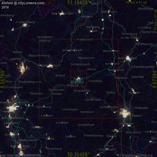
Analysis of Alsfeld night lights 2016
Square area 10x10 km:
 0%
0%90-99
0%80-89
1.07%70-79
0.27%60-69
0.27%50-59
1.2%40-49
0.4%30-39
0.8%20-29
1.07%10-19
1.87%0-9
93.05%Square area 50x50 km:
0.05%90-99
0.11%80-89
0.1%70-79
0.05%60-69
0.16%50-59
0.08%40-49
0.11%30-39
0.09%20-29
0.11%10-19
0.21%0-9
98.92%Clear (daylight) street map image can be seen on geolist.org.
Map coordinates:
51° 11' 40.5" North, 8° 34' 3.7" East
50° 45' 6.7" North, 9° 16' 15" East
50° 18' 17.6" North, 9° 58' 26.2" East
Some cities around Alsfeld sort by population:
• Stadtallendorf
19.8 km =12.3 mi,  293°
293°
• Schwalmstadt
20.5 km =12.7 mi,  349°
349°
• Lauterbach
15.7 km =9.8 mi,  145°
145°
• Neustadt (Hessen)
15.4 km =9.6 mi,  315°
315°
• Homberg
19.4 km =12.1 mi,  263°
263°
• Neukirchen
14.1 km =8.8 mi,  22°
22°
• Willingshausen
12 km =7.5 mi,  335°
335°
• Herbstein
21.9 km =13.6 mi,  165°
165°
2958128 (p: 17,771)
Sources (retrieved 2019-11-25):
» Earth at Night: Flat Maps 2012, 2016