Semily night lights from space
Night Light of Semily (Liberecký kraj) from space (Czech Republic) Src. Average luminocity for 10x10km area is 3.1818% and for 50x50km: 4.8956%.
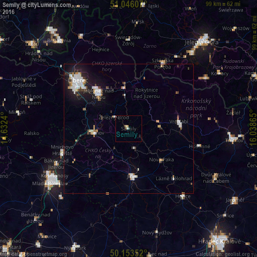
Analysis of Semily night lights 2016
Square area 10x10 km:
 0.67%
0.67%90-99
0.27%80-89
0.94%70-79
0%60-69
0%50-59
0.53%40-49
0.53%30-39
0.53%20-29
0.53%10-19
0%0-9
95.99%Square area 50x50 km:
1.13%90-99
0.92%80-89
0.28%70-79
0.45%60-69
0.39%50-59
0.52%40-49
0.4%30-39
0.58%20-29
0.94%10-19
3.4%0-9
90.99%Clear (daylight) street map image can be seen on geolist.org.
Map coordinates:
51° 2' 45.9" North, 14° 37' 56.6" East
50° 36' 6.9" North, 15° 20' 7.9" East
50° 9' 12.7" North, 16° 2' 19.1" East
Some cities around Semily sort by population:
• Jablonec nad Nisou
17.9 km =11.1 mi,  319°
319°
• Jičín
18.3 km =11.4 mi,  176°
176°
• Turnov
13.1 km =8.1 mi,  261°
261°
• Nová Paka
17.4 km =10.8 mi,  133°
133°
• Tanvald
15.2 km =9.4 mi,  352°
352°
• Železný Brod
7.3 km =4.5 mi,  308°
308°
• Lomnice nad Popelkou
8.4 km =5.2 mi,  161°
161°
• Jilemnice
12.1 km =7.5 mi,  86°
86°
3066220 (p: 9,040)
Sources (retrieved 2019-11-25):
» Earth at Night: Flat Maps 2012, 2016