Letohrad night lights from space
Night Light of Letohrad (Pardubický) from space (Czech Republic) Src. Average luminocity for 10x10km area is 2.1008% and for 50x50km: 2.0129%.
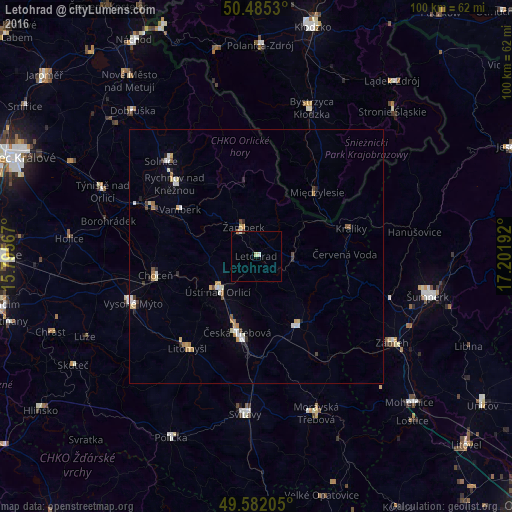
Analysis of Letohrad night lights 2016
Square area 10x10 km:
 0%
0%90-99
0.84%80-89
0.56%70-79
0%60-69
0.28%50-59
0%40-49
0.28%30-39
0%20-29
0%10-19
0%0-9
98.04%Square area 50x50 km:
0.31%90-99
0.38%80-89
0.21%70-79
0.3%60-69
0.28%50-59
0.11%40-49
0.23%30-39
0.15%20-29
0.27%10-19
0.11%0-9
97.65%Clear (daylight) street map image can be seen on geolist.org.
Map coordinates:
50° 29' 7.1" North, 15° 47' 44.4" East
50° 2' 8.9" North, 16° 29' 55.6" East
49° 34' 55.4" North, 17° 12' 6.9" East
Some cities around Letohrad sort by population:
• Česká Třebová
15.1 km =9.4 mi,  194°
194°
• Ústí nad Orlicí
10.2 km =6.3 mi,  227°
227°
• Rychnov nad Kněžnou
21.3 km =13.2 mi,  311°
311°
• Litomyšl
22.9 km =14.2 mi,  215°
215°
• Lanškroun
15.9 km =9.9 mi,  149°
149°
• Choceň
20.1 km =12.5 mi,  259°
259°
• Kostelec nad Orlicí
22.6 km =14 mi,  295°
295°
• Žamberk
6 km =3.7 mi,  338°
338°
3072134 (p: 6,195)
Sources (retrieved 2019-11-25):
» Earth at Night: Flat Maps 2012, 2016