Dobříš night lights from space
Night Light of Dobříš (Central Bohemia) from space (Czech Republic) Src. Average luminocity for 10x10km area is 1.9906% and for 50x50km: 4.2888%.
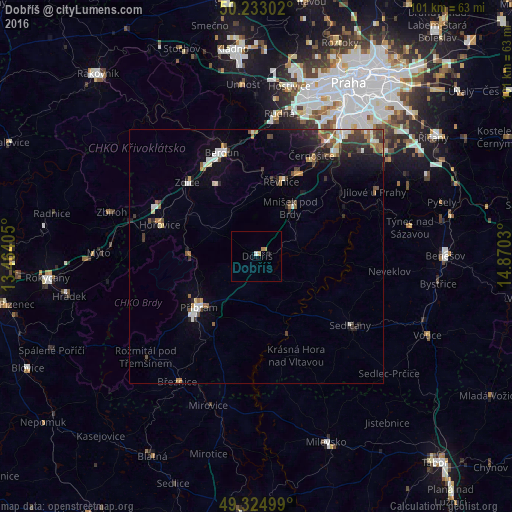
Analysis of Dobříš night lights 2016
Square area 10x10 km:
 0.4%
0.4%90-99
0.13%80-89
0.53%70-79
0.27%60-69
0.8%50-59
0%40-49
0%30-39
0%20-29
0%10-19
0.53%0-9
97.33%Square area 50x50 km:
0.5%90-99
0.71%80-89
0.34%70-79
0.36%60-69
0.64%50-59
0.63%40-49
0.56%30-39
0.77%20-29
1.1%10-19
2.67%0-9
91.73%Clear (daylight) street map image can be seen on geolist.org.
Map coordinates:
50° 13' 58.9" North, 13° 27' 50.6" East
49° 46' 52.1" North, 14° 10' 1.8" East
49° 19' 30" North, 14° 52' 13.1" East
Some cities around Dobříš sort by population:
• Příbram
15.2 km =9.4 mi,  227°
227°
• Modřany
30.9 km =19.2 mi,  34°
34°
• Braník
33.3 km =20.7 mi, 32°
• Beroun
21.4 km =13.3 mi,  341°
341°
• Sedlčany
23 km =14.3 mi,  125°
125°
• Hořovice
19.9 km =12.4 mi,  287°
287°
• Králův Dvůr
21 km =13 mi,  333°
333°
• Týnec nad Sázavou
30.9 km =19.2 mi,  79°
79°
3077024 (p: 7,926)
Sources (retrieved 2019-11-25):
» Earth at Night: Flat Maps 2012, 2016