Benátky nad Jizerou night lights from space
Night Light of Benátky nad Jizerou (Central Bohemia) from space (Czech Republic) Src. Average luminocity for 10x10km area is 3.6845% and for 50x50km: 10.2307%.
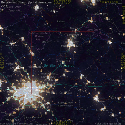
Analysis of Benátky nad Jizerou night lights 2016
Square area 10x10 km:
 0.13%
0.13%90-99
0.4%80-89
0.13%70-79
0.53%60-69
1.47%50-59
0.27%40-49
0.67%30-39
0.13%20-29
1.07%10-19
0%0-9
95.19%Square area 50x50 km:
2.72%90-99
2%80-89
0.68%70-79
1.13%60-69
1.04%50-59
0.78%40-49
0.68%30-39
1.2%20-29
2.22%10-19
5.62%0-9
81.93%Clear (daylight) street map image can be seen on geolist.org.
Map coordinates:
50° 44' 16.6" North, 14° 7' 13.1" East
50° 17' 27.1" North, 14° 49' 24.3" East
49° 50' 22.2" North, 15° 31' 35.6" East
Some cities around Benátky nad Jizerou sort by population:
• Mladá Boleslav
14.5 km =9 mi,  22°
22°
• Neratovice
22 km =13.7 mi,  260°
260°
• Brandýs nad Labem-Stará Boleslav
16.2 km =10.1 mi,  224°
224°
• Nymburk
19.4 km =12.1 mi,  126°
126°
• Čelákovice
15.4 km =9.6 mi,  199°
199°
• Lysá nad Labem
10 km =6.2 mi,  176°
176°
• Český Brod
24.2 km =15 mi,  173°
173°
• Milovice
8.6 km =5.3 mi,  147°
147°
3079514 (p: 6,818)
Sources (retrieved 2019-11-25):
» Earth at Night: Flat Maps 2012, 2016