Pacho night lights from space
Night Light of Pacho (Cundinamarca) from space (Colombia) Src. Average luminocity for 10x10km area is 3.0124% and for 50x50km: 5.931%.
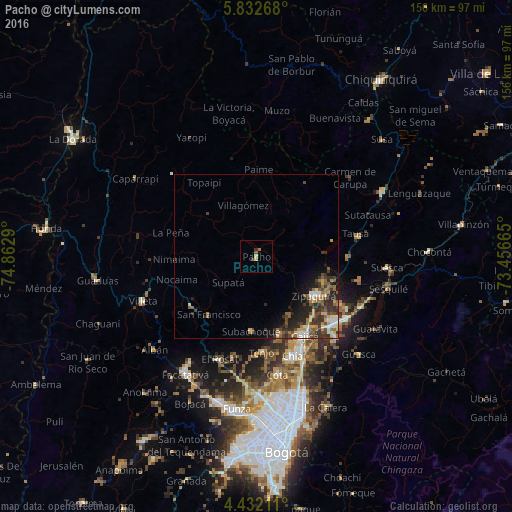
Analysis of Pacho night lights 2016
Square area 10x10 km:
 0%
0%90-99
0%80-89
0.62%70-79
1.03%60-69
0.21%50-59
1.45%40-49
0.21%30-39
0.83%20-29
0.62%10-19
0%0-9
95.04%Square area 50x50 km:
0.54%90-99
0.81%80-89
0.6%70-79
0.8%60-69
0.94%50-59
1.19%40-49
1.01%30-39
1.83%20-29
2.25%10-19
2.43%0-9
87.61%Clear (daylight) street map image can be seen on geolist.org.
Map coordinates:
5° 49' 57.6" North, 74° 51' 46.4" West
5° 7' 58" North, 74° 9' 35.2" West
4° 25' 55.6" North, 73° 27' 23.9" West
Some cities around Pacho sort by population:
• Zipaquirá
21.1 km =13.1 mi,  125°
125°
• Chía
32.5 km =20.2 mi,  159°
159°
• La Mesa
30.8 km =19.1 mi,  61°
61°
• Cajicá
27.9 km =17.3 mi,  148°
148°
• Tocancipá
33.1 km =20.6 mi,  124°
124°
• La Vega
24.9 km =15.5 mi,  234°
234°
• El Rosal
33 km =20.5 mi,  199°
199°
• Nemocón
32.1 km =19.9 mi,  103°
103°
3673424 (p: 16,698)
Sources (retrieved 2019-11-25):
» Earth at Night: Flat Maps 2012, 2016