Dakoutun night lights from space
Night Light of Dakoutun (Tianjin) from space (China) Src. Average luminocity for 10x10km area is 7.2192% and for 50x50km: 20.2097%.
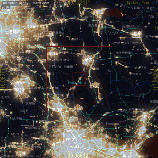
Analysis of Dakoutun night lights 2016
Square area 10x10 km:
 0%
0%90-99
0%80-89
1.14%70-79
0.16%60-69
0.81%50-59
1.79%40-49
1.3%30-39
2.76%20-29
1.14%10-19
2.76%0-9
88.15%Square area 50x50 km:
1.66%90-99
2.06%80-89
4.11%70-79
3.06%60-69
3.22%50-59
2.96%40-49
3.22%30-39
4.11%20-29
5.24%10-19
12.29%0-9
58.07%Clear (daylight) street map image can be seen on geolist.org.
Map coordinates:
40° 7' 23.2" North, 116° 31' 32.8" East
39° 34' 60" North, 117° 13' 44" East
39° 2' 21.6" North, 117° 55' 55.3" East
Some cities around Dakoutun sort by population:
• Yangcun
28.4 km =17.6 mi,  210°
210°
• Beicang
39.7 km =24.7 mi,  193°
193°
• Zaojiacheng
38.4 km =23.9 mi,  152°
152°
• Dongditou
37.3 km =23.2 mi,  160°
160°
• Xitangtuo
36.6 km =22.7 mi,  142°
142°
• Xiditou
38.1 km =23.7 mi, 164°
• Liukuaizhuang
38.5 km =23.9 mi,  165°
165°
• Xiaodian
36.6 km =22.7 mi,  180°
180°
1814123 (p: 5,814)
Sources (retrieved 2019-11-25):
» Earth at Night: Flat Maps 2012, 2016