Xitangtuo night lights from space
Night Light of Xitangtuo (Tianjin) from space (China) Src. Average luminocity for 10x10km area is 9.6497% and for 50x50km: 29.5026%.
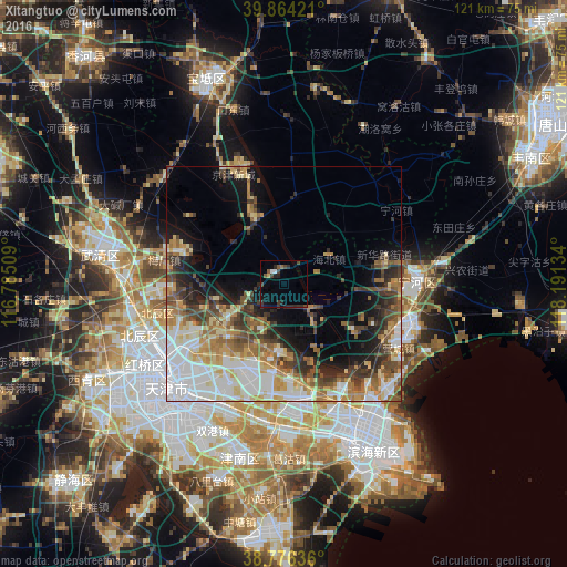
Analysis of Xitangtuo night lights 2016
Square area 10x10 km:
 0.68%
0.68%90-99
0.68%80-89
0.17%70-79
0.51%60-69
0.68%50-59
2.04%40-49
2.89%30-39
2.89%20-29
5.27%10-19
2.21%0-9
81.97%Square area 50x50 km:
6.92%90-99
4.79%80-89
4.18%70-79
3.74%60-69
4.33%50-59
3.68%40-49
4.65%30-39
4.42%20-29
4.59%10-19
8.36%0-9
50.33%Clear (daylight) street map image can be seen on geolist.org.
Map coordinates:
39° 51' 51.2" North, 116° 47' 6.3" East
39° 19' 20.6" North, 117° 29' 17.6" East
38° 46' 34.9" North, 118° 11' 28.8" East
Some cities around Xitangtuo sort by population:
• Chitu
15.1 km =9.4 mi,  209°
209°
• Beihuaidian
9.6 km =6 mi,  137°
137°
• Biaokou
5.6 km =3.5 mi,  86°
86°
• Zaojiacheng
6.8 km =4.2 mi,  221°
221°
• Dongditou
11.7 km =7.3 mi,  237°
237°
• Xiditou
14.3 km =8.9 mi, 237°
• Liukuaizhuang
15.3 km =9.5 mi, 237°
• Dawangtai
5.3 km =3.3 mi,  182°
182°
1788291 (p: 5,684)
Sources (retrieved 2019-11-25):
» Earth at Night: Flat Maps 2012, 2016