Zürich (Kreis 3) / Sihlfeld night lights from space
Night Light of Zürich (Kreis 3) / Sihlfeld (Zurich) from space (Switzerland) Src. Average luminocity for 10x10km area is 74.9866% and for 50x50km: 18.244%.

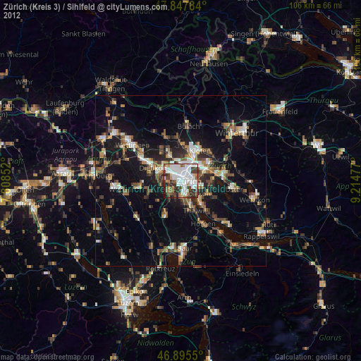
Analysis of Zürich (Kreis 3) / Sihlfeld night lights 2016
Square area 10x10 km:
 32.14%
90-99
20.98%80-89
4.46%70-79
4.17%60-69
6.55%50-59
4.32%40-49
7.14%30-39
11.76%20-29
4.76%10-19
3.72%0-9
0%Square area 50x50 km:
2.72%90-99
2.87%80-89
1.34%70-79
1.66%60-69
2.56%50-59
2.29%40-49
2.93%30-39
2.94%20-29
4.47%10-19
16.74%0-9
59.49%Clear (daylight) street map image can be seen on geolist.org.
Map coordinates:
47° 50' 52.2" North, 7° 48' 30.7" East
47° 22' 25.8" North, 8° 30' 41.9" East
46° 53' 43.8" North, 9° 12' 53.2" East
Some cities around Zürich (Kreis 3) / Sihlfeld sort by population:
• Zürich
3 km =1.9 mi,  105°
105°
• Adliswil
7.2 km =4.5 mi,  172°
172°
• Schlieren
5.4 km =3.4 mi,  297°
297°
• Urdorf
6.6 km =4.1 mi,  280°
280°
• Regensdorf
7.4 km =4.6 mi,  334°
334°
• Kilchberg
6.1 km =3.8 mi,  155°
155°
• Zollikon
6 km =3.7 mi,  128°
128°
• Oberengstringen
5.2 km =3.2 mi,  317°
317°
6295498 (p: 20,977)
Sources (retrieved 2019-11-25):
» Earth at Night: Flat Maps 2012, 2016