Zürich (Kreis 3) / Friesenberg night lights from space
Night Light of Zürich (Kreis 3) / Friesenberg (Zurich) from space (Switzerland) Src. Average luminocity for 10x10km area is 66.7827% and for 50x50km: 18.445%.
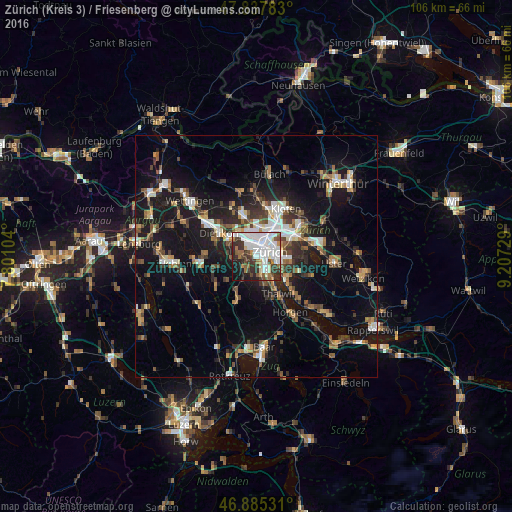
Analysis of Zürich (Kreis 3) / Friesenberg night lights 2016
Square area 10x10 km:
 28.42%
90-99
16.07%80-89
3.27%70-79
2.98%60-69
6.25%50-59
4.61%40-49
7.59%30-39
12.2%20-29
9.52%10-19
8.04%0-9
1.04%Square area 50x50 km:
2.74%90-99
2.92%80-89
1.33%70-79
1.71%60-69
2.57%50-59
2.31%40-49
2.95%30-39
2.98%20-29
4.56%10-19
16.76%0-9
59.17%Clear (daylight) street map image can be seen on geolist.org.
Map coordinates:
47° 50' 16.2" North, 7° 48' 3.7" East
47° 21' 49.4" North, 8° 30' 15" East
46° 53' 7.1" North, 9° 12' 26.2" East
Some cities around Zürich (Kreis 3) / Friesenberg sort by population:
• Zürich
3.5 km =2.2 mi,  84°
84°
• Adliswil
6.2 km =3.9 mi,  165°
165°
• Schlieren
5.6 km =3.5 mi,  310°
310°
• Küsnacht
7.9 km =4.9 mi,  130°
130°
• Urdorf
6.4 km =4 mi,  291°
291°
• Kilchberg
5.4 km =3.4 mi,  144°
144°
• Zollikon
5.9 km =3.7 mi,  116°
116°
• Oberengstringen
5.8 km =3.6 mi,  329°
329°
6295497 (p: 9,909)
Sources (retrieved 2019-11-25):
» Earth at Night: Flat Maps 2012, 2016