Zürich (Kreis 3) / Alt-Wiedikon night lights from space
Night Light of Zürich (Kreis 3) / Alt-Wiedikon (Zurich) from space (Switzerland) Src. Average luminocity for 10x10km area is 70.2307% and for 50x50km: 18.2769%.
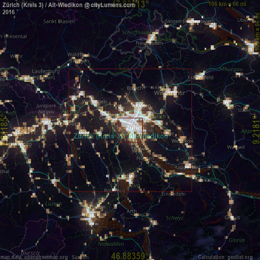
Analysis of Zürich (Kreis 3) / Alt-Wiedikon night lights 2016
Square area 10x10 km:
 28.72%
90-99
18.01%80-89
3.57%70-79
3.72%60-69
6.7%50-59
5.51%40-49
9.67%30-39
11.76%20-29
7.14%10-19
5.06%0-9
0.15%Square area 50x50 km:
2.74%90-99
2.88%80-89
1.31%70-79
1.66%60-69
2.56%50-59
2.28%40-49
2.94%30-39
2.95%20-29
4.52%10-19
16.68%0-9
59.5%Clear (daylight) street map image can be seen on geolist.org.
Map coordinates:
47° 50' 10.1" North, 7° 48' 42.7" East
47° 21' 43.2" North, 8° 30' 53.9" East
46° 53' 0.9" North, 9° 13' 5.2" East
Some cities around Zürich (Kreis 3) / Alt-Wiedikon sort by population:
• Zürich
2.7 km =1.7 mi,  78°
78°
• Adliswil
5.8 km =3.6 mi,  172°
172°
• Schlieren
6.4 km =4 mi,  307°
307°
• Küsnacht
7.1 km =4.4 mi,  133°
133°
• Urdorf
7.2 km =4.5 mi,  290°
290°
• Kilchberg
4.8 km =3 mi,  151°
151°
• Zollikon
5.1 km =3.2 mi,  118°
118°
• Oberengstringen
6.4 km =4 mi,  323°
323°
2658007 (p: 14,931)
Sources (retrieved 2019-11-25):
» Earth at Night: Flat Maps 2012, 2016