Zürich (Kreis 3) night lights from space
Night Light of Zürich (Kreis 3) (Zurich) from space (Switzerland) Src. Average luminocity for 10x10km area is 63.5119% and for 50x50km: 18.5091%.
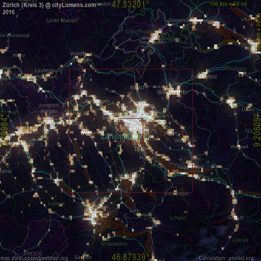

Analysis of Zürich (Kreis 3) night lights 2016
Square area 10x10 km:
 26.19%
90-99
13.84%80-89
3.27%70-79
3.27%60-69
6.25%50-59
4.61%40-49
8.48%30-39
12.2%20-29
10.71%10-19
9.38%0-9
1.79%Square area 50x50 km:
2.74%90-99
2.92%80-89
1.33%70-79
1.73%60-69
2.59%50-59
2.33%40-49
2.98%30-39
2.98%20-29
4.57%10-19
16.75%0-9
59.09%Clear (daylight) street map image can be seen on geolist.org.
Map coordinates:
47° 49' 55.2" North, 7° 47' 59.4" East
47° 21' 28.3" North, 8° 30' 10.7" East
46° 52' 45.8" North, 9° 12' 21.9" East
Some cities around Zürich (Kreis 3) sort by population:
• Zürich
3.7 km =2.3 mi,  74°
74°
• Adliswil
5.6 km =3.5 mi,  162°
162°
• Schlieren
6 km =3.7 mi,  316°
316°
• Küsnacht
7.5 km =4.7 mi,  125°
125°
• Urdorf
6.6 km =4.1 mi,  297°
297°
• Kilchberg
4.9 km =3 mi,  139°
139°
• Zollikon
5.7 km =3.5 mi,  110°
110°
• Oberengstringen
6.3 km =3.9 mi,  333°
333°
6295532 (p: 46,018)
Sources (retrieved 2019-11-25):
» Earth at Night: Flat Maps 2012, 2016