Zürich (Kreis 11) / Affoltern night lights from space
Night Light of Zürich (Kreis 11) / Affoltern (Zurich) from space (Switzerland) Src. Average luminocity for 10x10km area is 75.7869% and for 50x50km: 17.6735%.
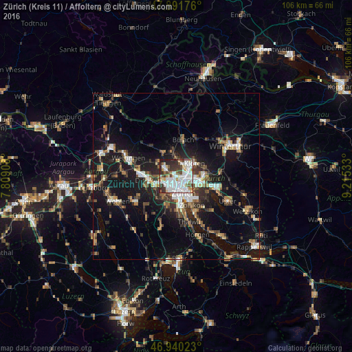
Analysis of Zürich (Kreis 11) / Affoltern night lights 2016
Square area 10x10 km:
 31.53%
90-99
22.87%80-89
6.53%70-79
3.55%60-69
3.27%50-59
5.11%40-49
6.53%30-39
10.37%20-29
8.66%10-19
1.56%0-9
0%Square area 50x50 km:
2.68%90-99
2.77%80-89
1.35%70-79
1.57%60-69
2.52%50-59
2.12%40-49
2.91%30-39
2.93%20-29
4.39%10-19
16.05%0-9
60.69%Clear (daylight) street map image can be seen on geolist.org.
Map coordinates:
47° 53' 30.3" North, 7° 48' 32.7" East
47° 25' 5.3" North, 8° 30' 43.9" East
46° 56' 24.8" North, 9° 12' 55.2" East
Some cities around Zürich (Kreis 11) / Affoltern sort by population:
• Zürich
6.4 km =4 mi,  153°
153°
• Kloten
6.6 km =4.1 mi,  55°
55°
• Schlieren
5.4 km =3.4 mi,  243°
243°
• Wallisellen
6.4 km =4 mi,  93°
93°
• Regensdorf
3.7 km =2.3 mi,  298°
298°
• Oberengstringen
3.7 km =2.3 mi,  253°
253°
• Rümlang
3.8 km =2.4 mi,  20°
20°
• Wallisellen / Wallisellen-Ost
6.4 km =4 mi, 93°
6295484 (p: 17,241)
Sources (retrieved 2019-11-25):
» Earth at Night: Flat Maps 2012, 2016