Kloten night lights from space
Night Light of Kloten (Zurich) from space (Switzerland) Src. Average luminocity for 10x10km area is 46.9489% and for 50x50km: 15.5253%.
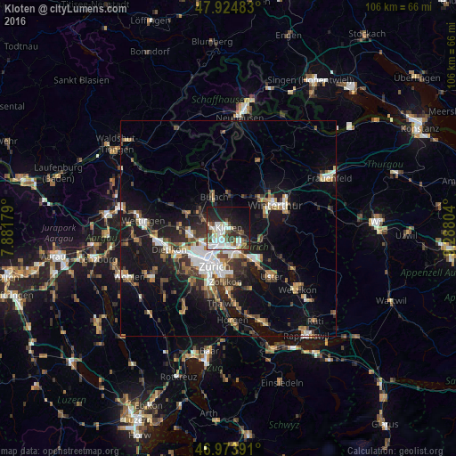
Analysis of Kloten night lights 2016
Square area 10x10 km:
 13.07%
90-99
13.35%80-89
4.26%70-79
1.14%60-69
2.56%50-59
5.11%40-49
5.97%30-39
7.24%20-29
12.07%10-19
23.86%0-9
11.36%Square area 50x50 km:
2.58%90-99
2.5%80-89
1.3%70-79
1.28%60-69
2.05%50-59
1.69%40-49
2.55%30-39
2.65%20-29
3.96%10-19
12.76%0-9
66.69%Clear (daylight) street map image can be seen on geolist.org.
Map coordinates:
47° 55' 29.4" North, 7° 52' 54.4" East
47° 27' 5.5" North, 8° 35' 5.7" East
46° 58' 26.1" North, 9° 17' 16.9" East
Some cities around Kloten sort by population:
• Zürich (Kreis 11) / Seebach
4.3 km =2.7 mi,  220°
220°
• Wallisellen
4.2 km =2.6 mi,  167°
167°
• Zürich (Kreis 12) / Schwamendingen-Mitte
5.1 km =3.2 mi,  190°
190°
• Bassersdorf
3.4 km =2.1 mi,  105°
105°
• Dietlikon / Dietlikon (Dorf)
4.5 km =2.8 mi,  145°
145°
• Zürich (Kreis 12) / Saatlen
4.7 km =2.9 mi,  198°
198°
• Rümlang
4.1 km =2.5 mi,  268°
268°
• Wallisellen / Wallisellen-Ost
4.2 km =2.6 mi, 167°
2660127 (p: 16,289)
Sources (retrieved 2019-11-25):
» Earth at Night: Flat Maps 2012, 2016