Stans night lights from space
Night Light of Stans (Nidwalden) from space (Switzerland) Src. Average luminocity for 10x10km area is 7.2514% and for 50x50km: 5.4249%.
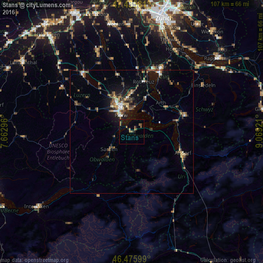
Analysis of Stans night lights 2016
Square area 10x10 km:
100  0%
0%
90-99 0%
80-89 0.14%
70-79 1.85%
60-69 2.13%
50-59 1.56%
40-49 1.14%
30-39 0.57%
20-29 0.99%
10-19 7.1%
0-9 84.52%
0%90-99
0%80-89
0.14%70-79
1.85%60-69
2.13%50-59
1.56%40-49
1.14%30-39
0.57%20-29
0.99%10-19
7.1%0-9
84.52%Square area 50x50 km:
100 0.35%
90-99 0.57%
80-89 0.46%
70-79 0.59%
60-69 0.91%
50-59 1.01%
40-49 1.11%
30-39 0.97%
20-29 1.56%
10-19 3.55%
0-9 88.91%
0.35%90-99
0.57%80-89
0.46%70-79
0.59%60-69
0.91%50-59
1.01%40-49
1.11%30-39
0.97%20-29
1.56%10-19
3.55%0-9
88.91%Clear (daylight) street map image can be seen on geolist.org.
Map coordinates:
47° 26' 8.9" North, 7° 39' 46.7" East
46° 57' 29" North, 8° 21' 57.9" East
46° 28' 33.6" North, 9° 4' 9.2" East
Some cities around Stans sort by population:
• Luzern
11.2 km =7 mi,  336°
336°
• Kriens
10.2 km =6.3 mi,  323°
323°
• Horw
7.8 km =4.8 mi,  326°
326°
• Meggen
9.9 km =6.2 mi,  3°
3°
• Buochs
4.7 km =2.9 mi,  67°
67°
• Hergiswil
5.2 km =3.2 mi,  304°
304°
• Alpnach
7.4 km =4.6 mi,  256°
256°
• Kerns
9.4 km =5.8 mi,  227°
227°
2658504 (p: 7,475)
Sources (retrieved 2019-11-25):
» Earth at Night: Flat Maps 2012, 2016