Alpnach night lights from space
Night Light of Alpnach (Obwalden) from space (Switzerland) Src. Average luminocity for 10x10km area is 3.5369% and for 50x50km: 4.4829%.
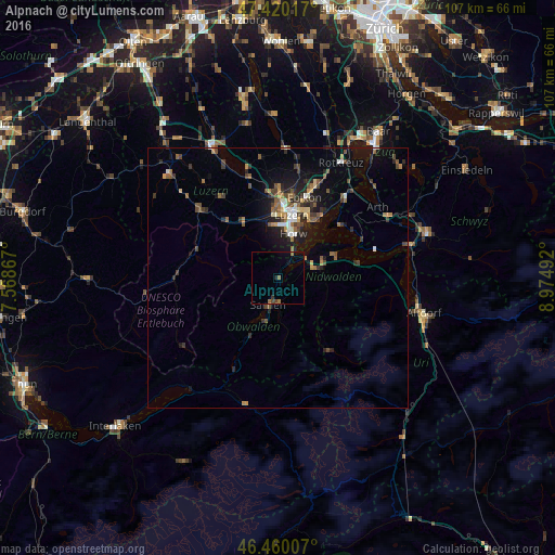
Analysis of Alpnach night lights 2016
Square area 10x10 km:
100  0%
0%
90-99 0%
80-89 0%
70-79 0%
60-69 1.56%
50-59 0.71%
40-49 1.14%
30-39 0.28%
20-29 0.71%
10-19 1.42%
0-9 94.18%
0%90-99
0%80-89
0%70-79
0%60-69
1.56%50-59
0.71%40-49
1.14%30-39
0.28%20-29
0.71%10-19
1.42%0-9
94.18%Square area 50x50 km:
100 0.29%
90-99 0.46%
80-89 0.35%
70-79 0.42%
60-69 0.74%
50-59 0.84%
40-49 0.91%
30-39 0.94%
20-29 1.35%
10-19 3.15%
0-9 90.55%
0.29%90-99
0.46%80-89
0.35%70-79
0.42%60-69
0.74%50-59
0.84%40-49
0.91%30-39
0.94%20-29
1.35%10-19
3.15%0-9
90.55%Clear (daylight) street map image can be seen on geolist.org.
Map coordinates:
47° 25' 12.6" North, 7° 34' 7.2" East
46° 56' 32.2" North, 8° 16' 18.5" East
46° 27' 36.3" North, 8° 58' 29.7" East
Some cities around Alpnach sort by population:
• Kriens
9.9 km =6.2 mi,  5°
5°
• Littau
12 km =7.5 mi,  356°
356°
• Horw
8.8 km =5.5 mi,  19°
19°
• Sarnen
5.5 km =3.4 mi,  201°
201°
• Stans
7.4 km =4.6 mi,  76°
76°
• Buochs
12 km =7.5 mi,  72°
72°
• Hergiswil
5.5 km =3.4 mi,  31°
31°
• Kerns
4.6 km =2.9 mi,  176°
176°
2661789 (p: 5,218)
Sources (retrieved 2019-11-25):
» Earth at Night: Flat Maps 2012, 2016