Hinwil night lights from space
Night Light of Hinwil (Zurich) from space (Switzerland) Src. Average luminocity for 10x10km area is 12.3244% and for 50x50km: 11.6647%.
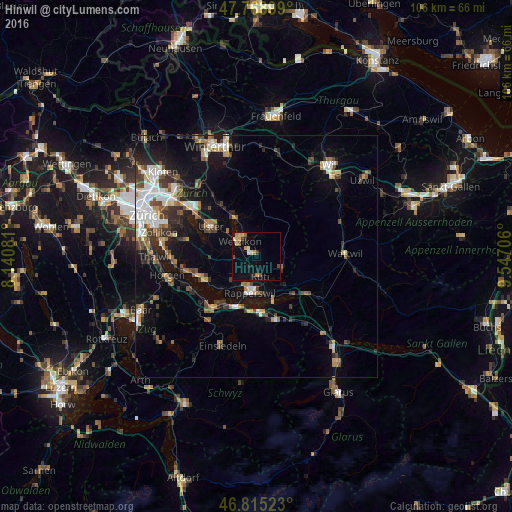
Analysis of Hinwil night lights 2016
Square area 10x10 km:
 0.3%
0.3%90-99
1.19%80-89
1.93%70-79
3.13%60-69
1.19%50-59
0.89%40-49
2.23%30-39
1.19%20-29
1.79%10-19
5.36%0-9
80.8%Square area 50x50 km:
1.87%90-99
1.88%80-89
0.99%70-79
1.17%60-69
1.52%50-59
1.37%40-49
2.04%30-39
1.68%20-29
2.76%10-19
6.9%0-9
77.83%Clear (daylight) street map image can be seen on geolist.org.
Map coordinates:
47° 46' 8.4" North, 8° 8' 26.9" East
47° 17' 39.3" North, 8° 50' 38.1" East
46° 48' 54.8" North, 9° 32' 49.4" East
Some cities around Hinwil sort by population:
• Rapperswil
7.8 km =4.8 mi,  192°
192°
• Jona
7.2 km =4.5 mi,  183°
183°
• Wetzikon
5 km =3.1 mi,  315°
315°
• Rüti
4.3 km =2.7 mi,  168°
168°
• Eschenbach
8.4 km =5.2 mi,  135°
135°
• Pfäffikon
8.7 km =5.4 mi,  333°
333°
• Pfäffikon / Pfäffikon (Dorfkern)
9.5 km =5.9 mi, 331°
• Uster / Ober-Uster
10.3 km =6.4 mi,  305°
305°
2660338 (p: 5,488)
Sources (retrieved 2019-11-25):
» Earth at Night: Flat Maps 2012, 2016