Silver Berry night lights from space
Night Light of Silver Berry (Alberta) from space (Canada) Src. Average luminocity for 10x10km area is 61.9497% and for 50x50km: 29.1992%.
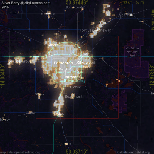
Analysis of Silver Berry night lights 2016
Square area 10x10 km:
 10.71%
90-99
17.46%80-89
13.1%70-79
8.33%60-69
8.6%50-59
7.67%40-49
5.29%30-39
3.17%20-29
9.66%10-19
10.05%0-9
5.95%Square area 50x50 km:
8.12%90-99
7.93%80-89
3.7%70-79
3.67%60-69
2.36%50-59
2.54%40-49
1.92%30-39
2.54%20-29
5.38%10-19
7.54%0-9
54.29%Clear (daylight) street map image can be seen on geolist.org.
Map coordinates:
53° 52' 28.1" North, 114° 5' 5.4" West
53° 27' 28.3" North, 113° 22' 54.1" West
53° 2' 13.7" North, 112° 40' 42.9" West
Some cities around Silver Berry sort by population:
• Edmonton
11.8 km =7.3 mi,  330°
330°
• St. Albert
25.7 km =16 mi,  319°
319°
• Sherwood Park
7.8 km =4.8 mi,  32°
32°
• Leduc
24.1 km =15 mi,  208°
208°
• Fort Saskatchewan
30.7 km =19.1 mi,  20°
20°
• Wild Rose
1.4 km =0.9 mi,  1°
1°
• Beaumont
12.2 km =7.6 mi,  191°
191°
• Devon
25.5 km =15.8 mi,  246°
246°
11203928 (p: 8,089)
Sources (retrieved 2019-11-25):
» Earth at Night: Flat Maps 2012, 2016