Sainte-Adèle night lights from space
Night Light of Sainte-Adèle (Quebec) from space (Canada) Src. Average luminocity for 10x10km area is 20.3616% and for 50x50km: 8.4035%.
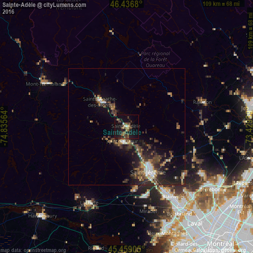
Analysis of Sainte-Adèle night lights 2016
Square area 10x10 km:
 0.45%
0.45%90-99
0.74%80-89
2.38%70-79
2.23%60-69
1.34%50-59
6.7%40-49
5.51%30-39
2.23%20-29
5.36%10-19
32.59%0-9
40.48%Square area 50x50 km:
0.66%90-99
0.95%80-89
0.67%70-79
0.82%60-69
0.99%50-59
1.35%40-49
2.31%30-39
1.95%20-29
3.68%10-19
6.67%0-9
79.95%Clear (daylight) street map image can be seen on geolist.org.
Map coordinates:
46° 26' 12.5" North, 74° 50' 8.3" West
45° 57' 0.3" North, 74° 7' 57" West
45° 27' 32.6" North, 73° 25' 45.8" West
Some cities around Sainte-Adèle sort by population:
• Blainville
37 km =23 mi,  148°
148°
• Mirabel
33.6 km =20.9 mi,  173°
173°
• Prévost
10 km =6.2 mi,  157°
157°
• Lorraine
40.2 km =25 mi,  137°
137°
• Lachute
36.8 km =22.9 mi,  204°
204°
• Bois-des-Filion
43.3 km =26.9 mi, 136°
• Brownsburg-Chatham
36.9 km =22.9 mi,  216°
216°
• Rawdon
34 km =21.1 mi,  70°
70°
6137696 (p: 10,634)
Sources (retrieved 2019-11-25):
» Earth at Night: Flat Maps 2012, 2016