Mont-Tremblant night lights from space
Night Light of Mont-Tremblant (Quebec) from space (Canada) Src. Average luminocity for 10x10km area is 4.6477% and for 50x50km: 1.7433%.
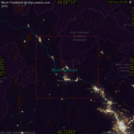
Analysis of Mont-Tremblant night lights 2016
Square area 10x10 km:
 0%
0%90-99
0%80-89
0.99%70-79
0.71%60-69
0.57%50-59
0.57%40-49
1.14%30-39
0.85%20-29
1.42%10-19
1.85%0-9
91.9%Square area 50x50 km:
0.11%90-99
0.18%80-89
0.16%70-79
0.21%60-69
0.35%50-59
0.28%40-49
0.39%30-39
0.21%20-29
0.52%10-19
0.42%0-9
97.17%Clear (daylight) street map image can be seen on geolist.org.
Map coordinates:
46° 41' 49.7" North, 75° 17' 15" West
46° 12' 45.9" North, 74° 35' 3.8" West
45° 43' 26.5" North, 73° 52' 52.5" West
Some cities around Mont-Tremblant sort by population:
• Sainte-Adèle
45.5 km =28.3 mi,  129°
129°
• Prévost
54.6 km =33.9 mi, 134°
• Lachute
65.5 km =40.7 mi,  162°
162°
• Saint-Sauveur
47.8 km =29.7 mi,  139°
139°
• Saint-Hippolyte
53.7 km =33.4 mi, 125°
• Saint-Sauveur-des-Monts
47.4 km =29.5 mi, 137°
• Brownsburg-Chatham
60.3 km =37.5 mi,  167°
167°
• Sainte-Agathe-des-Monts
29.5 km =18.3 mi, 127°
6077445 (p: 8,892)
Sources (retrieved 2019-11-25):
» Earth at Night: Flat Maps 2012, 2016