Pio XII night lights from space
Night Light of Pio XII (Maranhão) from space (Brazil) Src. Average luminocity for 10x10km area is 0.8961% and for 50x50km: 2.9862%.
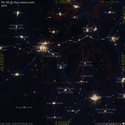
Analysis of Pio XII night lights 2016
Square area 10x10 km:
 0%
0%90-99
0%80-89
0%70-79
0%60-69
0%50-59
0%40-49
0%30-39
1.52%20-29
0.65%10-19
0%0-9
97.84%Square area 50x50 km:
0.14%90-99
0.31%80-89
0.49%70-79
0.34%60-69
0.42%50-59
0.76%40-49
0.62%30-39
0.74%20-29
0.81%10-19
1.44%0-9
93.93%Clear (daylight) street map image can be seen on geolist.org.
Map coordinates:
3° 7' 50.4" South, 45° 51' 20.3" West
3° 49' 57" South, 45° 9' 9" West
4° 32' 1.5" South, 44° 26' 57.8" West
Some cities around Pio XII sort by population:
• Santa Inês
31.3 km =19.4 mi,  306°
306°
• Lago da Pedra
51.4 km =31.9 mi,  190°
190°
• Pindaré Mirim
32.7 km =20.3 mi,  319°
319°
• Arari
59 km =36.7 mi,  44°
44°
• Vitória do Mearim
51.7 km =32.1 mi, 37°
• Vitorino Freire
25.2 km =15.7 mi,  202°
202°
• Monção
39.4 km =24.5 mi,  343°
343°
• Paulo Ramos
42.9 km =26.7 mi,  184°
184°
3392018 (p: 14,773)
Sources (retrieved 2019-11-25):
» Earth at Night: Flat Maps 2012, 2016