Morro Agudo night lights from space
Night Light of Morro Agudo (São Paulo) from space (Brazil) Src. Average luminocity for 10x10km area is 13.4508% and for 50x50km: 3.817%.
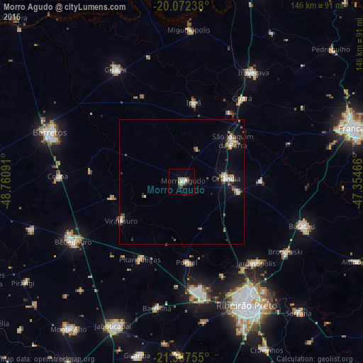

Analysis of Morro Agudo night lights 2016
Square area 10x10 km:
 1.7%
1.7%90-99
2.08%80-89
0.38%70-79
3.41%60-69
2.84%50-59
1.7%40-49
1.52%30-39
0.57%20-29
0.95%10-19
0%0-9
84.85%Square area 50x50 km:
0.52%90-99
0.49%80-89
0.09%70-79
0.73%60-69
0.66%50-59
0.52%40-49
0.52%30-39
0.52%20-29
0.33%10-19
2.27%0-9
93.35%Clear (daylight) street map image can be seen on geolist.org.
Map coordinates:
20° 4' 20.6" South, 48° 45' 39.3" West
20° 43' 53" South, 48° 3' 28" West
21° 23' 15.2" South, 47° 21' 16.8" West
Some cities around Morro Agudo sort by population:
• Orlândia
17.8 km =11.1 mi,  86°
86°
• São Joaquim da Barra
26.9 km =16.7 mi,  51°
51°
• Pontal
32.4 km =20.1 mi,  176°
176°
• Pitangueiras
35.3 km =21.9 mi,  208°
208°
• Guará
41.6 km =25.8 mi,  35°
35°
• Viradouro
29.4 km =18.3 mi,  237°
237°
• Ipuã
33 km =20.5 mi,  8°
8°
• Nuporanga
31.8 km =19.8 mi, 89°
3456724 (p: 25,265)
Sources (retrieved 2019-11-25):
» Earth at Night: Flat Maps 2012, 2016