Martinópolis night lights from space
Night Light of Martinópolis (São Paulo) from space (Brazil) Src. Average luminocity for 10x10km area is 15.4444% and for 50x50km: 5.5921%.
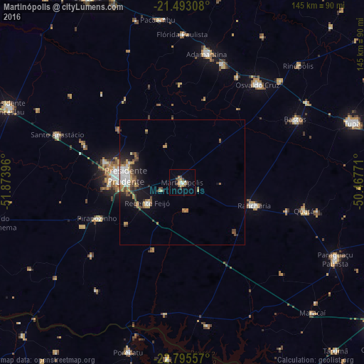
Analysis of Martinópolis night lights 2016
Square area 10x10 km:
 1.98%
1.98%90-99
1.19%80-89
0.99%70-79
5.16%60-69
1.19%50-59
0.6%40-49
4.96%30-39
1.39%20-29
0%10-19
1.79%0-9
80.75%Square area 50x50 km:
0.81%90-99
0.78%80-89
0.44%70-79
1.05%60-69
0.72%50-59
0.48%40-49
1.4%30-39
0.66%20-29
1.01%10-19
3.04%0-9
89.61%Clear (daylight) street map image can be seen on geolist.org.
Map coordinates:
21° 29' 35.1" South, 51° 52' 26.3" West
22° 8' 45" South, 51° 10' 15" West
22° 47' 44.1" South, 50° 28' 3.8" West
Some cities around Martinópolis sort by population:
• Presidente Prudente
22.6 km =14 mi,  275°
275°
• Osvaldo Cruz
49.1 km =30.5 mi,  37°
37°
• Rancharia
30.1 km =18.7 mi,  107°
107°
• Pirapozinho
36.8 km =22.9 mi,  246°
246°
• Álvares Machado
31.9 km =19.8 mi, 283°
• Regente Feijó
16 km =9.9 mi,  238°
238°
• Lucélia
49.8 km =30.9 mi,  18°
18°
• Presidente Bernardes
42.3 km =26.3 mi,  291°
291°
3457595 (p: 18,488)
Sources (retrieved 2019-11-25):
» Earth at Night: Flat Maps 2012, 2016