Lagoa night lights from space
Night Light of Lagoa (Santa Catarina) from space (Brazil) Src. Average luminocity for 10x10km area is 50.3988% and for 50x50km: 23.0689%.
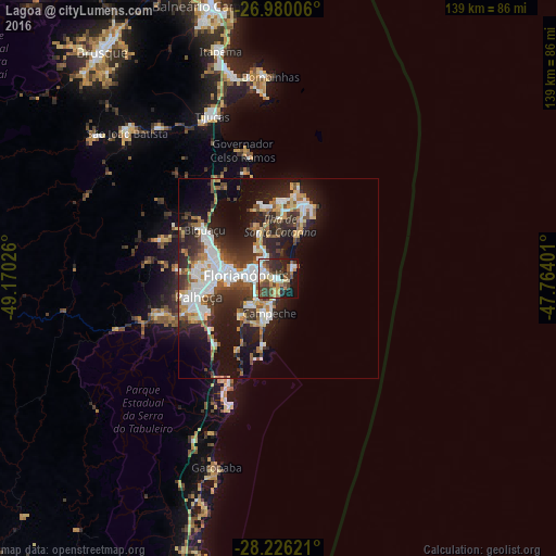
Analysis of Lagoa night lights 2016
Square area 10x10 km:
 7.34%
7.34%90-99
10.71%80-89
3.77%70-79
6.75%60-69
6.35%50-59
9.33%40-49
13.49%30-39
11.51%20-29
11.9%10-19
15.87%0-9
2.98%Square area 50x50 km:
4.62%90-99
4.7%80-89
2.15%70-79
2.16%60-69
2.35%50-59
3.06%40-49
3.16%30-39
4.02%20-29
7.72%10-19
13.14%0-9
52.91%Clear (daylight) street map image can be seen on geolist.org.
Map coordinates:
26° 58' 48.2" South, 49° 10' 12.9" West
27° 36' 17.7" South, 48° 28' 1.7" West
28° 13' 34.4" South, 47° 45' 50.4" West
Some cities around Lagoa sort by population:
• Florianópolis
8.1 km =5 mi,  276°
276°
• Ribeirão da Ilha
12.3 km =7.6 mi,  211°
211°
• Campinas
13.8 km =8.6 mi,  274°
274°
• Trindade
5.9 km =3.7 mi,  290°
290°
• Saco dos Limoes
6.8 km =4.2 mi, 266°
• Itacorubi
3.7 km =2.3 mi,  311°
311°
• Costeira do Pirajubae
6.3 km =3.9 mi,  237°
237°
• Santa Monica
4.3 km =2.7 mi, 290°
3459303 (p: 5,200)
Sources (retrieved 2019-11-25):
» Earth at Night: Flat Maps 2012, 2016