Ibirubá night lights from space
Night Light of Ibirubá (Rio Grande do Sul) from space (Brazil) Src. Average luminocity for 10x10km area is 12.9129% and for 50x50km: 1.8424%.
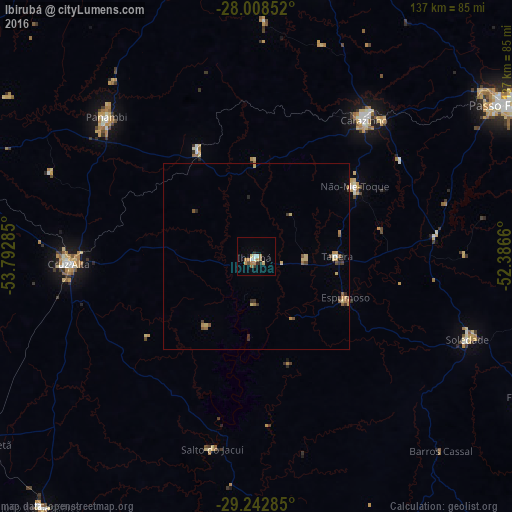
Analysis of Ibirubá night lights 2016
Square area 10x10 km:
 1.7%
1.7%90-99
1.33%80-89
1.52%70-79
3.41%60-69
1.52%50-59
1.89%40-49
0.76%30-39
1.33%20-29
1.7%10-19
0.38%0-9
84.47%Square area 50x50 km:
0.09%90-99
0.09%80-89
0.41%70-79
0.36%60-69
0.31%50-59
0.31%40-49
0.19%30-39
0.37%20-29
0.25%10-19
0.07%0-9
97.55%Clear (daylight) street map image can be seen on geolist.org.
Map coordinates:
28° 0' 30.7" South, 53° 47' 34.3" West
28° 37' 39" South, 53° 5' 23" West
29° 14' 34.3" South, 52° 23' 11.8" West
Some cities around Ibirubá sort by population:
• Passo Fundo
78.1 km =48.5 mi,  58°
58°
• Cruz Alta
50.4 km =31.3 mi,  267°
267°
• Carazinho
48.4 km =30.1 mi,  37°
37°
• Panambi
54.9 km =34.1 mi,  312°
312°
• Soledade
60.4 km =37.5 mi,  110°
110°
• Sarandi
77.7 km =48.3 mi,  12°
12°
• Não Me Toque
32.3 km =20.1 mi,  54°
54°
• Espumoso
25.8 km =16 mi, 114°
3461559 (p: 14,180)
Sources (retrieved 2019-11-25):
» Earth at Night: Flat Maps 2012, 2016