Cerro Largo night lights from space
Night Light of Cerro Largo (Rio Grande do Sul) from space (Brazil) Src. Average luminocity for 10x10km area is 8.8182% and for 50x50km: 1.349%.
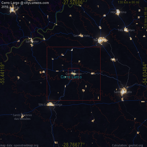
Analysis of Cerro Largo night lights 2016
Square area 10x10 km:
 0%
0%90-99
0%80-89
2.27%70-79
0.76%60-69
4.55%50-59
0.76%40-49
1.52%30-39
1.52%20-29
0%10-19
0.76%0-9
87.88%Square area 50x50 km:
0.02%90-99
0.06%80-89
0.34%70-79
0.42%60-69
0.29%50-59
0.09%40-49
0.2%30-39
0.3%20-29
0.08%10-19
0.06%0-9
98.15%Clear (daylight) street map image can be seen on geolist.org.
Map coordinates:
27° 31' 36.7" South, 55° 26' 28.3" West
28° 8' 55" South, 54° 44' 17" West
28° 46' 0.4" South, 54° 2' 5.8" West
Some cities around Cerro Largo sort by population:
• Santo Ângelo
49.5 km =30.8 mi,  109°
109°
• Santa Rosa
39.9 km =24.8 mi,  39°
39°
• São Luiz Gonzaga
36.2 km =22.5 mi,  217°
217°
• Três de Maio
64.3 km =40 mi,  49°
49°
• Horizontina
71.9 km =44.7 mi, 36°
• Giruá
40.4 km =25.1 mi,  70°
70°
• Alba Posse, AR
64.6 km =40.1 mi,  4°
4°
• Panambí, AR
50.3 km =31.3 mi,  339°
339°
3466395 (p: 9,548)
Sources (retrieved 2019-11-25):
» Earth at Night: Flat Maps 2012, 2016