Cachoeira night lights from space
Night Light of Cachoeira (Bahia) from space (Brazil) Src. Average luminocity for 10x10km area is 49.3874% and for 50x50km: 20.3446%.
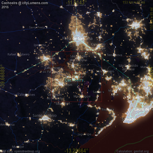
Analysis of Cachoeira night lights 2016
Square area 10x10 km:
 1.08%
1.08%90-99
12.34%80-89
2.38%70-79
6.49%60-69
11.69%50-59
15.8%40-49
8.01%30-39
9.09%20-29
20.78%10-19
11.69%0-9
0.65%Square area 50x50 km:
0.41%90-99
2.54%80-89
1.5%70-79
1.67%60-69
3.3%50-59
5.82%40-49
5.27%30-39
5.39%20-29
7.6%10-19
13.81%0-9
52.7%Clear (daylight) street map image can be seen on geolist.org.
Map coordinates:
11° 54' 51.5" South, 39° 40' 8" West
12° 36' 5" South, 38° 57' 56.7" West
13° 17' 11.9" South, 38° 15' 45.5" West
Some cities around Cachoeira sort by population:
• Cruz das Almas
16.6 km =10.3 mi,  242°
242°
• Santo Amaro
28.2 km =17.5 mi,  77°
77°
• Maragogipe
20.2 km =12.6 mi,  165°
165°
• Sobradinho
29.6 km =18.4 mi,  209°
209°
• Conceição da Feira
11.2 km =7 mi,  341°
341°
• Saubara
26.2 km =16.3 mi,  125°
125°
• São Gonçalo dos Campos
18.7 km =11.6 mi,  359°
359°
• Conceição do Almeida
29.7 km =18.5 mi,  228°
228°
3468535 (p: 16,145)
Sources (retrieved 2019-11-25):
» Earth at Night: Flat Maps 2012, 2016