Butiá night lights from space
Night Light of Butiá (Rio Grande do Sul) from space (Brazil) Src. Average luminocity for 10x10km area is 14.1496% and for 50x50km: 2.0888%.
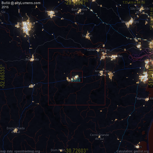
Analysis of Butiá night lights 2016
Square area 10x10 km:
 0.76%
0.76%90-99
0.95%80-89
3.79%70-79
2.08%60-69
0.76%50-59
4.36%40-49
0.19%30-39
3.03%20-29
0.76%10-19
3.79%0-9
79.55%Square area 50x50 km:
0.03%90-99
0.1%80-89
0.5%70-79
0.28%60-69
0.34%50-59
0.6%40-49
0.2%30-39
0.35%20-29
0.17%10-19
0.58%0-9
96.85%Clear (daylight) street map image can be seen on geolist.org.
Map coordinates:
29° 30' 34.8" South, 52° 39' 55.3" West
30° 7' 11" South, 51° 57' 44" West
30° 43' 33.7" South, 51° 15' 32.8" West
Some cities around Butiá sort by population:
• Guaíba
61.3 km =38.1 mi,  89°
89°
• Venâncio Aires
61.2 km =38 mi,  338°
338°
• Charqueadas
37.3 km =23.2 mi,  60°
60°
• Taquari
36.8 km =22.9 mi,  14°
14°
• Rio Pardo
42.6 km =26.5 mi,  289°
289°
• São Jerônimo
29.2 km =18.1 mi,  52°
52°
• Triunfo
30.6 km =19 mi, 50°
• Arroio dos Ratos
22.9 km =14.2 mi,  78°
78°
3468704 (p: 19,494)
Sources (retrieved 2019-11-25):
» Earth at Night: Flat Maps 2012, 2016