Gustavia night lights from space
Night Light of Gustavia from space (Saint Barthelemy) Src. Average luminocity for 10x10km area is 7.8593% and for 50x50km: 2.9997%.
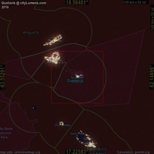
Analysis of Gustavia night lights 2016
Square area 10x10 km:
 0.43%
0.43%90-99
0.43%80-89
2.16%70-79
1.3%60-69
0%50-59
0.87%40-49
2.38%30-39
3.03%20-29
1.52%10-19
1.73%0-9
86.15%Square area 50x50 km:
0.37%90-99
0.43%80-89
0.52%70-79
0.59%60-69
0.66%50-59
0.2%40-49
0.23%30-39
0.33%20-29
0.57%10-19
2.01%0-9
94.11%Clear (daylight) street map image can be seen on geolist.org.
Map coordinates:
18° 33' 50.4" North, 63° 33' 10.5" West
17° 53' 46.2" North, 62° 50' 59.2" West
17° 13' 33" North, 62° 8' 48" West
Some cities around Gustavia sort by population:
• Cul de Sac, SX
28.4 km =17.6 mi,  306°
306°
• Lower Prince’s Quarter, SX
26.2 km =16.3 mi, 310°
• Koolbaai, SX
29.5 km =18.3 mi,  302°
302°
• Marigot, MF
31.2 km =19.4 mi, 307°
• Philipsburg, SX
25.3 km =15.7 mi, 304°
• The Quarter, AI
40.2 km =25 mi,  329°
329°
• Sandy Hill, AI
40 km =24.9 mi, 334°
• Farrington, AI
39.9 km =24.8 mi, 332°
3579132 (p: 5,988)
Sources (retrieved 2019-11-25):
» Earth at Night: Flat Maps 2012, 2016