Chirpan night lights from space
Night Light of Chirpan (Stara Zagora) from space (Bulgaria) Src. Average luminocity for 10x10km area is 5.2424% and for 50x50km: 3.0337%.
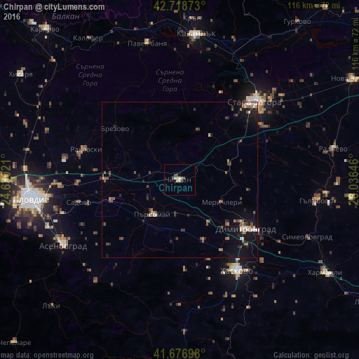
Analysis of Chirpan night lights 2016
Square area 10x10 km:
 0%
0%90-99
1.21%80-89
0.91%70-79
0.91%60-69
0.61%50-59
0.61%40-49
1.67%30-39
0.76%20-29
0%10-19
0%0-9
93.33%Square area 50x50 km:
0.18%90-99
0.45%80-89
0.11%70-79
0.39%60-69
0.34%50-59
0.66%40-49
0.62%30-39
0.45%20-29
0.91%10-19
2.46%0-9
93.42%Clear (daylight) street map image can be seen on geolist.org.
Map coordinates:
42° 43' 7.4" North, 24° 37' 48.8" East
42° 12' 0" North, 25° 19' 60" East
41° 40' 37.1" North, 26° 2' 11.3" East
Some cities around Chirpan sort by population:
• Stara Zagora
36.2 km =22.5 mi,  44°
44°
• Haskovo
34.8 km =21.6 mi,  148°
148°
• Asenovgrad
43.6 km =27.1 mi,  242°
242°
• Dimitrovgrad
27.6 km =17.1 mi,  127°
127°
• Parvomay
14.7 km =9.1 mi,  220°
220°
• Rakovski
33.3 km =20.7 mi,  284°
284°
• Gŭlŭbovo
43.2 km =26.8 mi,  99°
99°
• Simeonovgrad
45.2 km =28.1 mi,  114°
114°
732452 (p: 17,243)
Sources (retrieved 2019-11-25):
» Earth at Night: Flat Maps 2012, 2016