Vosselaar night lights from space
Night Light of Vosselaar (Flanders) from space (Belgium) Src. Average luminocity for 10x10km area is 44.2031% and for 50x50km: 20.6521%.
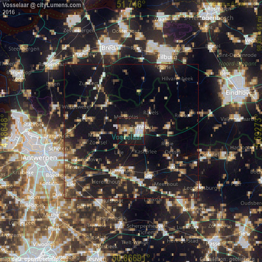
Analysis of Vosselaar night lights 2016
Square area 10x10 km:
 8.68%
8.68%90-99
8.68%80-89
4.2%70-79
6.86%60-69
5.74%50-59
3.5%40-49
4.62%30-39
2.52%20-29
20.87%10-19
33.75%0-9
0.56%Square area 50x50 km:
1.74%90-99
2.17%80-89
1.84%70-79
2.05%60-69
2.59%50-59
3.62%40-49
3.93%30-39
3.48%20-29
7.73%10-19
27.66%0-9
43.18%Clear (daylight) street map image can be seen on geolist.org.
Map coordinates:
51° 44' 45.6" North, 4° 11' 11.3" East
51° 18' 30.8" North, 4° 53' 22.6" East
50° 52' 0.9" North, 5° 35' 33.8" East
Some cities around Vosselaar sort by population:
• Turnhout
4.1 km =2.5 mi,  67°
67°
• Kasterlee
9.2 km =5.7 mi,  144°
144°
• Beerse
2.8 km =1.7 mi,  295°
295°
• Lille
8.7 km =5.4 mi,  211°
211°
• Ravels
10.1 km =6.3 mi,  44°
44°
• Oud-Turnhout
6.7 km =4.2 mi,  79°
79°
• Rijkevorsel
10 km =6.2 mi, 296°
• Merksplas
5.8 km =3.6 mi,  342°
342°
2784349 (p: 10,317)
Sources (retrieved 2019-11-25):
» Earth at Night: Flat Maps 2012, 2016