Momignies night lights from space
Night Light of Momignies (Wallonia) from space (Belgium) Src. Average luminocity for 10x10km area is 2.8838% and for 50x50km: 3.4504%.
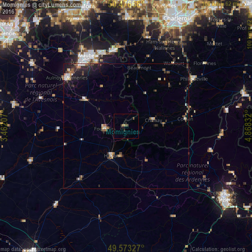
Analysis of Momignies night lights 2016
Square area 10x10 km:
 0%
0%90-99
0%80-89
0.56%70-79
0%60-69
0.42%50-59
1.26%40-49
0.56%30-39
0.84%20-29
0.98%10-19
0.84%0-9
94.54%Square area 50x50 km:
0.3%90-99
0.49%80-89
0.32%70-79
0.25%60-69
0.38%50-59
0.62%40-49
0.69%30-39
0.73%20-29
1.1%10-19
2.08%0-9
93.04%Clear (daylight) street map image can be seen on geolist.org.
Map coordinates:
50° 28' 36" North, 3° 27' 43.5" East
50° 1' 37.6" North, 4° 9' 54.7" East
49° 34' 23.8" North, 4° 52' 6" East
Some cities around Momignies sort by population:
• Fourmies, FR
8.5 km =5.3 mi,  261°
261°
• Couvin
23.7 km =14.7 mi,  83°
83°
• Hirson, FR
13 km =8.1 mi,  206°
206°
• Chimay
11.1 km =6.9 mi, 77°
• Aulnoye-Aymeries, FR
30.3 km =18.8 mi,  309°
309°
• Louvroil, FR
30.1 km =18.7 mi,  331°
331°
• Beaumont
23.9 km =14.9 mi,  12°
12°
• Ferrière-la-Grande, FR
28.2 km =17.5 mi, 334°
2790906 (p: 5,183)
Sources (retrieved 2019-11-25):
» Earth at Night: Flat Maps 2012, 2016