Merchtem night lights from space
Night Light of Merchtem (Flanders) from space (Belgium) Src. Average luminocity for 10x10km area is 46.9818% and for 50x50km: 57.4095%.
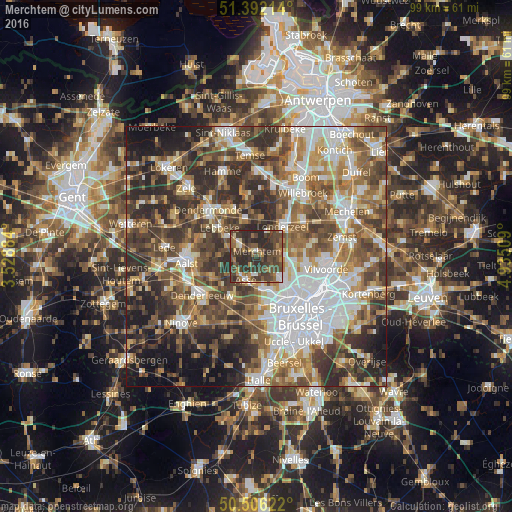
Analysis of Merchtem night lights 2016
Square area 10x10 km:
 3.08%
3.08%90-99
4.2%80-89
2.52%70-79
5.18%60-69
7.7%50-59
10.36%40-49
24.93%30-39
17.65%20-29
24.09%10-19
0.28%0-9
0%Square area 50x50 km:
12.51%90-99
10.45%80-89
5.6%70-79
6.8%60-69
9.18%50-59
10.5%40-49
11.52%30-39
11.09%20-29
13.12%10-19
7.94%0-9
1.3%Clear (daylight) street map image can be seen on geolist.org.
Map coordinates:
51° 23' 31.7" North, 3° 31' 43.8" East
50° 57' 4.6" North, 4° 13' 55.1" East
50° 30' 22.4" North, 4° 56' 6.3" East
Some cities around Merchtem sort by population:
• Grimbergen
10 km =6.2 mi,  101°
101°
• Asse
5.1 km =3.2 mi,  207°
207°
• Meise
6.8 km =4.2 mi, 101°
• Lebbeke
9 km =5.6 mi,  311°
311°
• Londerzeel
7.7 km =4.8 mi,  39°
39°
• Wemmel
7.1 km =4.4 mi,  132°
132°
• Buggenhout
7.5 km =4.7 mi,  343°
343°
• Opwijk
3.8 km =2.4 mi,  298°
298°
2791323 (p: 14,660)
Sources (retrieved 2019-11-25):
» Earth at Night: Flat Maps 2012, 2016